“There are several trails up Otto, including a steep one right under the cable car.”
Cerro Otto on foot: the trail under the cable car
The direct climb up Cerro Otto: steep, through the forest and with the whole city at your feet
Great for
520 m of climbing in 1.6 km.
Nahuel Huapi, Gutiérrez and Cerro Catedral.
If it gets too much, by buying a ticket.
The bus stops at the base.
Not for: Beginners or small kids: it is very steep · Rainy or muddy days · Winter with snow
What to do there
Cerro Otto (1,405 m) is the city's mountain. The most direct trail starts at the cable car base and climbs almost straight up under the cables, through the forest: on OpenStreetMap it appears as "A Cerro Otto (Difícil)".
At the top is the cable car complex, with the revolving café, viewpoints and a panoramic deck. If it gets too much, you can ride the cable car down by buying a ticket.
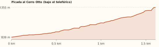
Trail profile
Cable car base → near the summit
- Length
- 1.6 km
- Elevations
- 839 → 1,355 m (summit: 1,405 m)
- Elevation gain
- +520 m (+≈560 to the summit)
- Uphill
- ≈1 h 30–1 h 40
- Downhill
- ≈1 h
- Difficulty
- Hard: 32% average gradient
Another way up: from km 1 of Av. de los Pioneros
- Length
- Longer
- Elevations
- —
- Elevation gain
- 350 m (Bariloche Trekking)
- Out
- —
- Back
- 5–6 h round trip to Piedra de Habsburgo
- Difficulty
- Easy according to the guide
The trail appears on OpenStreetMap as "A Cerro Otto (Difícil)", rated as demanding mountain terrain. Times calculated at an easy pace, without stops.
How to get there
Car, taxi or remis
5.8 km · about 8 min from the Civic Center
- Take Av. de los Pioneros to km 5.
- Park at the cable car base (free).
Bus
Lines 50, 51 and 55 · get off at the base
- Take line 50 (A, B or C), 51 or 55A.
- Get off at "Pioneros – Teleférico".
- The cable car also offers a free shuttle from downtown.
The trail
1.6 km · 520 m elevation gain · ≈1 h 30 up
- It starts next to the base and climbs under the cable car line.
- There are many forks: follow the most direct one uphill or use a map.
- It is very steep, with loose dirt: good shoes and poles help on the way down (≈1 h).
What it's like, in numbers
Few people. The trail is quiet; the summit has the cable car crowds. To be checked
Several hours or a lot of climbing. A lot of elevation gain in a short distance.
Mostly natural. Forest and views, with the cable car overhead.
Exposed. Exposed summit. To be checked
Several bus lines at the door. Bus stop at the base.
Quite a few. Café, toilets and viewpoints at the summit (paid).
Older kids only. Only for older, fit kids.
What you want to know
Does it cost money?
The trail is free. According to Bariloche Trekking, entering the summit complex is paid even if you arrive on foot (to be confirmed). The cable car costs about ARS 60,000 (Jun. 2026).
- TrailARS 0
- Entering the summit complexTo be confirmedBariloche Trekking says access to the complex and the café is paid even if you arrive on foot. To be checked
- Cable car≈ARS 60,000 generalARS 30,000 for residents and people over 65 (Diario Río Negro, Jun. 2026).
- ParkingARS 0At the base.
- Bus (one way)ARS 2,333.30With a SUBE card. Standard fare for sections I to III; residents with a registered SUBE card ARS 1,749.98 (since 30/07/2026).
Can I bring my dog?
On the trail, on a leash. Don't count on entering the complex or the cable car with your dog. To be checked
What the rules say
The trail is outside the National Park (measured). The summit is a private complex and we couldn't find its rule on dogs.
What happens in practice
No clear reports.
Context
Pets are not allowed in Nahuel Huapi National Park or in Llao Llao Municipal Park (guide dogs only).
- What's the easiest way to get there?
- Bus or car
Lines 50, 51, 55. Get off 100 m away.
- How long does it take?
- 3 h to 4 h 30
Walking 2 h 30 a 4 h + 8 min by car each way.
- Are there toilets or food?
- Yes
At the summit complex. Revolving café at the summit.
- When is the best time?
- Good time right now
Spring to autumn. In winter there is snow and part of the trails belongs to the cross-country ski center. The cable car closes in May for maintenance.
Reviews
“Many forks: it is easy to get lost.”
If you like this place…
Refugio Berghof (Cerro Otto)
Great for: a hut 15 minutes from downtown · learning about Bariloche's history
Cerro Campanario
Great for: the panoramic photo of Bariloche · a short but steep climb
Stupa of Enlightenment
Great for: watching the sunset · a moment of silence
Fact sheet
- Type
- Hiking and walks · Viewpoints
- Activities
- Steep hike · Viewpoint · Revolving café at the summit · Ride down by cable car
- Area
- Av. de los Pioneros km 5
- Location
- Base of the Cerro Otto Cable Car, Av. de los Pioneros km 5
- Distance from the Civic Center
- 5.8 km · 8 min by car · 1 h 14 on foot
- Time walking
- 2 h 30 a 4 h (climb, summit and descent)
- Whole outing by car
- 3 h to 4 h 30
- Trail length
- 1.6 km uphill (3.2 km round trip)
- Route type
- Out and back (or ride the cable car down)
- Elevation gain
- +520 m (≈560 m to the summit)
- Elevation
- ≈840 m s.n.m. · max. 1,405 m above sea level (summit)
- Difficulty
- Hard because of the slope
- Terrain
- Loose dirt and rock, very steep
- Signposting
- Many forks: follow the cable car line
- Water on the way
- None
- Nearby bus lines
- 50, 51, 55 (stop 100 m away)
- Gravel road
- No, paved all the way
- Toilets
- Yes · At the summit complex
- Food
- Yes · Revolving café at the summit
- Lifeguards
- No · Not applicable
- Shade
- Yes · Forest on the way up
- Phone signal
- Yes · Good
- Best months
- Oct, Nov, Dec, Jan, Feb, Mar, Apr, May
- Dogs
- Grey area
- Cost
- Trail is free
- Data checked on
- November 18, 2026
What to bring
- Sneakers or boots with good grip
- Water
- A windbreaker
- Poles for the descent
Tips
- If in doubt, walk up and ride the cable car down.
- Check the forecast: with mud it gets very slippery.
Safety
- Very steep slope: take it easy.
- Not a good idea in rain or snow.
Sources for this page (5)
Most sources are in Spanish.
- Piedra de Habsburgo – Cerro Otto – Bariloche Trekking · consultado 18/11/2026
- Teleférico Cerro Otto – Lonely Planet · s/f
- Cerro Otto: promoción y tarifas – Diario Río Negro · jun. 2026
- OpenStreetMap: picada "A Cerro Otto (Difícil)", paradas y límites · consultado 18/11/2026
- Tarifas de colectivo (Res. 2283/2026) – El Cordillerano · 31/07/2026
Photos: Dario Alpern (CC BY-SA 4.0), Dario Alpern (CC BY-SA 4.0), Dario Alpern (CC BY-SA 4.0), Thomas Woodtli (CC BY-SA 2.0), Brandon Antonio Segura Torres (CC BY-SA 4.0), via Wikimedia Commons.