All places

Refugio Berghof (Cerro Otto)

Otto Meiling's house on Cerro Otto, at 1,240 m: reach it on foot, by cable car or by car

Great for

A hut 15 minutes from downtown

No long drives or roads with set hours.

Learning about Bariloche's history

Otto Meiling's house.

Combining it with the cable car

Ride up by cable car and walk down.

Not for: Going without checking it's open: it doesn't publish opening hours · Looking for a high-mountain hut

The experience

What to do there

A mountain house with history: Otto Meiling lived here, made the area's first skis and set up South America's first ski resort. Today it is a Club Andino hut.

It is the closest hut to downtown: hike up from the cable car base on Av. de los Pioneros, or ride the cable car up and walk down the road. It doesn't publish opening hours or prices: contact them before you go.

The hut

The hut: what's there and how to ask

History

Otto Meiling's house and South America's first ski resort.

Open

Reopened in April 2025 under new operators; check the opening hours.

By car

You can drive there on the Cerro Otto road.

Contact

hola@berghof.com.ar (its website isn't active)

It is the hut with the least public information: contact them before you go.
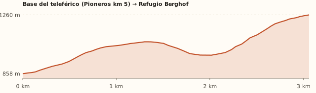
Elevation

Trail profile

Elevation profile: Cable car base → Refugio Berghof

Cable car base → Refugio Berghof

Length
3.1 km
Elevations
860 → 1.260 m
Elevation gain
+495 m / −90 m
Out
≈2 h
Back
≈1 h 30
Difficulty
Moderate
  1. It starts at the cable car base, at Av. de los Pioneros km 5.
  2. It climbs the slope of Cerro Otto up to the road.
  3. A sign marks the entrance to the hut.

Summit of Otto (cable car) → Refugio Berghof

Length
≈2 km
Elevations
1.405 → 1.240 m
Elevation gain
Descent
Out
≈30–40 min
Back
≈45 min uphill
Difficulty
Easy
  1. Ride the cable car up to the revolving café.
  2. Walk down the road to the Berghof sign (Club Andino).

We measured the climb from the base on OpenStreetMap trails; the Club Andino gives 6 km, 600 m and 2 h. Times calculated at an easy pace, without stops.

Location and directions

How to get there

You arrive at: Cerro Otto cable car base (Av. de los Pioneros km 5). The hike up starts at the base; you can also ride the cable car up and walk down the road to the hut's sign.

Car, taxi or remis

5.8 km · 8 min to the cable car base

Where to park: Cable car base To be checked
Parking at the cable car base. View on Google Maps
Busy area; still, don't leave anything in sight.
  1. Take Av. de los Pioneros to km 5: that's where the cable car base is.
  2. The hut can also be reached by car on the Cerro Otto road.
Open this route in Google Maps
Ratings from 1 to 5

What it's like, in numbers

How crowded is it?2/5
Very few peopleVery crowded

Few people. Cerro Otto is busy, but the hut is off to one side. To be checked

How physically demanding is it?3/5
Very easyVery hard

Slopes or uneven ground. 2 h of sustained climbing from the base; walking down from the summit, easy.

How much nature is there?3/5
Very littleA lot

Nature with houses or a road nearby. Forest on the slope, with the city below.

Does it work on a windy day?3/5
Very exposedVery sheltered

Some shelter. The slope offers some shelter. To be checked

Is it easy to get there without a car?4/5
HardVery easy

Bus stop under 300 m away. Buses to the cable car base.

Are there facilities?2/5
NoneFull

Minimal. To be confirmed with the hut. To be checked

Is it good with kids?3/5
Not recommendedIdeal

With supervision. Walking down from the cable car, suitable for kids. To be checked

In 10 seconds

What you want to know

Does it cost money?

Free!

Walking to the hut is free. The Cerro Otto cable car is paid separately; ask about the hut's services.

  • Hiking upARS 0By the trail or the road.
  • Cerro Otto cable carAskPaid at the base, at Av. de los Pioneros km 5. To be checked
  • Food or a bed at the hutAskNo published prices: hola@berghof.com.ar. To be checked
  • Bus (one way)ARS 2,333.30With a SUBE card. Standard fare for sections I to III; residents with a registered SUBE pay ARS 1,749.98 (since 30/07/2026).

Can I bring my dog?

Grey area

Ask before going with your dog. To be checked

What the rules say

Cerro Otto is outside the National Park (measured). We couldn't find the hut's pet policy.

What happens in practice

No reports.

Context

Pets are not allowed in Nahuel Huapi National Park or in Llao Llao Municipal Park (guide dogs only).

What's the easiest way to get there?
Bus or car

Lines 50, 51, 55. Get off 300 m away.

How long does it take?
3 h 30 to 4 h 30

Round-trip hike 3 a 4 h + 8 min by car each way.

Do I need to book?
Ask first

No published hours or services: write to hola@berghof.com.ar.

Are there toilets or food?
Yes

At the hut (if open). To be confirmed with the hut.

When is the best time?
Good time right now

Spring, summer and autumn on foot. In winter there's snow on Otto.

What people say

Reviews

What media, guides and visitors say
Media, guides and forums

“You can reach the hut by car, or ride the cable car up and walk down to the sign.”

Club Andino Bariloche
All reviews and photosOpen Refugio Berghof (Cerro Otto) in Google Maps

If you like this place…

Fact sheet

Type
Mountain huts · Hiking and walks · Viewpoints
Activities
Hike up · Cable car · Bariloche history · Viewpoint
Area
Cerro Otto
Location
On the slope of Cerro Otto, at about 1,240 m
Distance from the Civic Center
5.8 km · 8 min by car
Time round-trip hike
3 a 4 h (about 2 h up from the cable car base)
Whole outing by car
3 h 30 to 4 h 30
Trail length
≈3 km up (6 km round trip)
Route type
Out and back, or up by cable car and down on foot
Elevation gain
≈+500 m from the cable car base
Elevation
≈860 m at Av. de los Pioneros km 5 · max. ≈1.260 m
Difficulty
Moderate: a sustained climb
Terrain
Forest trail and gravel road
Signposting
Sign on the road that comes down from the cable car
Water on the way
No water along the way
Nearby bus lines
50, 51, 55 (stop 300 m away)
Gravel road
Yes, on the last stretch
Toilets
Yes · At the hut (if open)
Food
Yes · To be confirmed with the hut
Lifeguards
No · Not applicable
Shade
Yes · Forest on the slope
Phone signal
Yes · Good (close to the city)
Best months
Jan, Feb, Mar, Apr, May, Sep, Oct, Nov, Dec
Dogs
Grey area
Cost
Free on foot
Data checked on
November 19, 2026

What to bring

  • Water
  • Windbreaker
  • Shoes with good soles

Tips

  • Write ahead to find out if it's open.
  • Ride the cable car up and walk down: it's the most comfortable option.

Safety

  • The Otto road has car traffic: walk on the side.
Sources for this page (5)

Most sources are in Spanish.

Photos: Dario Alpern (CC BY-SA 4.0), Juan E De Cristofaro (CC BY-SA 2.0), via Wikimedia Commons.