“The walk up is short but has a steep slope that takes some effort: between 30 and 45 minutes.”
Cerro Campanario
Bariloche's most famous viewpoint: go up by chairlift or walk up in 45 minutes
Great for
360° of lakes, islands and mountains.
1 km and 240 m of elevation gain, about 45 minutes.
With the chairlift, everyone gets to the top.
Almost every bus line on Bustillo stops at the base.
In summer the sun sets around 9:15 pm, after the chairlift has closed.
Not for: Very windy days: the summit is very exposed · Looking for peace and quiet in January or July
What to do there
A small hill right next to Bustillo Avenue. At the top there is a café with a terrace and viewpoints in every direction: Lake Nahuel Huapi, Lake Moreno, the Llao Llao peninsula and the Andes. This is where the classic Bariloche photo is taken.
You can ride the chairlift up in about 7 minutes or walk up a 1 km trail that starts to the right of the entrance and climbs 240 m through the forest in about 45 minutes. Many people walk up and ride down, or the other way around.
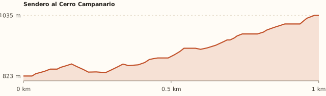
Trail profile
Chairlift base → summit
- Length
- 1.0 km
- Elevations
- 823 → 1,035 m (summit: 1,049 m)
- Elevation gain
- +252 m
- Uphill
- ≈45–55 min
- Downhill
- ≈35–40 min
- Difficulty
- Moderate: steep
Bariloche Trekking gives 1 km, 240 m of elevation gain and 1 h 30 round trip. Times calculated at an easy pace, without stops.
How to get there
Car, taxi or remis
17.4 km · about 23 min from the Civic Center
- Take Av. San Martín west and keep going on Av. Bustillo.
- Drive about 17 km along Bustillo: street numbers go by meters, so look for number 17,500.
- The chairlift base is on your left, on the avenue, with a parking lot next to it.
- Taxi or remis (private car service): ask for "base de la aerosilla del Cerro Campanario, Bustillo km 17,5".
Bus
Lines 10, 13, 20 and 51 · get off 150 m away
- Take line 10, 13, 20 or 51 heading west along Bustillo.
- Get off at "Bustillo 17500 – Cerro Campanario": the base is about 150 m away.
- Payment: SUBE card only.
Walking up
1 km · 240 m elevation gain · 45 min up
- The trail starts to the right of the chairlift entrance.
- It climbs through the forest with steep dirt sections: wear good shoes.
- In about 45 minutes you reach the summit, with the café and the viewpoints.
- To come down you can take the same trail (about 35 min) or ride the chairlift down by buying a ticket.
What it's like, in numbers
Packed in high season. It is the most visited stop on the Circuito Chico; the top gets crowded in high season.
Slopes or uneven ground. On foot it is short but climbs 240 m in 1 km. By chairlift it is 1/5.
Nature with houses or a road nearby. Forest and a huge view, but with a chairlift, a café and the avenue at the foot of the hill.
Very exposed. The summit is completely exposed. To be checked
Several bus lines at the door. Several bus lines stop 150 m from the base.
Quite a few. Café, toilets and viewpoints at the summit; chairlift.
Good. Ideal by chairlift; on foot, for kids who walk well. Be careful near the edges of the viewpoints.
What you want to know
Does it cost money?
Walking up is free according to the guides. The chairlift costs about ARS 30,000 round trip (August 2026).
- Walking upARS 0Guides present it as a free option. It is private land: confirm at the base. To be checked
- Chairlift (round trip)≈ARS 30,000Bariloche residents get 50% off with their ID. Kids aged 5 to 12, ARS 15,000; under 4, free (Diario ENE, Aug. 2026).
- ParkingARS 0Next to the base (Bariloche Trekking).
- Bus (one way)ARS 2,333.30With a SUBE card. Standard fare for sections I to III; residents with a registered SUBE card ARS 1,749.98 (since 30/07/2026).
Can I bring my dog?
Don't bring your dog until you confirm it at the base. To be checked
What the rules say
It is not inside the National Park or Llao Llao Municipal Park (measured). It is private land run under a concession and we couldn't find its rule on dogs.
What happens in practice
No reports. Dogs are most likely not allowed on the chairlift.
Context
Pets are not allowed in Nahuel Huapi National Park or in Llao Llao Municipal Park (guide dogs only).
- What's the easiest way to get there?
- Bus or car
Lines 10, 13, 20, 51. Get off 150 m away.
- How long does it take?
- 2 h 30 to 4 h
On site 1 h 30 a 3 h + 23 min by car each way.
- Are there toilets or food?
- Yes
At the summit (café). Café at the summit.
- When is the best time?
- Good time right now
All year round, on clear days. Avoid very windy days.
Reviews
“It is a free option for anyone who doesn't want to pay for the chairlift.”
If you like this place…
Refugio Berghof (Cerro Otto)
Great for: a hut 15 minutes from downtown · learning about Bariloche's history
Casa de Piedra Stream Trail
Great for: a short forest walk · mate or a picnic by the stream
Lake Gutiérrez Viewpoint
Great for: a short climb with a big view · adding it to Cascada de los Duendes
Fact sheet
- Type
- Viewpoints · Hiking and walks
- Activities
- 360° viewpoint · Hike up · Chairlift · Café at the summit
- Area
- Av. Bustillo km 17.5
- Location
- Av. Exequiel Bustillo km 17.5, base of the Cerro Campanario chairlift
- Distance from the Civic Center
- 17.4 km · 23 min by car · 3 h 55 on foot
- Time on site
- 1 h 30 a 3 h (on foot, with time at the top; by chairlift, 1 to 1 h 30)
- Whole outing by car
- 2 h 30 to 4 h
- Trail length
- 1 km uphill (2 km round trip)
- Route type
- Out and back, or walk up and ride the chairlift down
- Elevation gain
- ≈+250 m
- Elevation
- ≈820 m above sea level at the base · max. 1,049 m above sea level (summit)
- Difficulty
- Easy to moderate: short but steep
- Terrain
- Dirt, with steep sections
- Signposting
- Starts to the right of the chairlift entrance
- Water on the way
- No water along the way
- Nearby bus lines
- 10, 13, 20, 51 (stop 150 m away)
- Gravel road
- No, paved all the way
- Toilets
- Yes · At the summit (café)
- Food
- Yes · Café at the summit
- Lifeguards
- No · Not applicable
- Shade
- Yes · Forest along the trail
- Phone signal
- Yes · Good (urban area)
- Best months
- Jan, Feb, Mar, Apr, May, Jun, Jul, Aug, Sep, Oct, Nov, Dec
- Dogs
- Grey area
- Cost
- Free on foot
- Data checked on
- November 18, 2026
What to bring
- A windbreaker: it is always windy at the top
- Shoes with good grip if you walk up
- Water
- Cash for the ticket office (people say it is more reliable)
Tips
- Walk up and ride the chairlift down to skip the steep descent.
- Go early in January and during the winter holidays.
- Combine it with Laguna El Trébol, 2 km away.
Safety
- Be careful near the edges of the viewpoints, especially with kids.
- When muddy, the trail gets slippery.
Sources for this page (6)
Most sources are in Spanish.
- Campanario peak – Bariloche Trekking · consultado 18/11/2026
- Siete trekkings cortos – ANBariloche · 11/11/2026
- Cerro Campanario: aerosilla, precios y cómo llegar en 2026 – Diario ENE · 10/08/2026
- Cerro Campanario – Billiken · s/f
- OpenStreetMap: aerosilla, sendero, paradas y líneas · consultado 18/11/2026
- Tarifas de colectivo (Res. 2283/2026) – El Cordillerano · 31/07/2026
Photos: bullit (CC BY 3.0), Hiroki Ogawa (CC BY 3.0), bullit (CC BY 3.0), Elvis Boaventura (CC BY 3.0), Hiroki Ogawa (CC BY 3.0), via Wikimedia Commons.