All places
Closed for works. National Parks closed the trail on 20/04/2026 to build a new route with steps and expects to reopen it in late November 2026. As of 17/11 there was still no reopening announcement: don't go in while it is closed. See the official notice

Lake Gutiérrez Viewpoint

A short, steep climb from the ranger station to a view over all of Lake Gutiérrez

Great for

A short climb with a big view

About 150 to 180 m of elevation gain in 1.4 km.

Adding it to Cascada de los Duendes

Both start from the same place.

Starting with toilets

New toilet block at the ranger station (June 2026).

Not for: Going before it reopens · Going with a dog: it is a National Park · Small kids or smooth-soled shoes: it is steep · Muddy days, or May to October without experience

The experience

What to do there

The trail starts just like the one to Cascada de los Duendes: opposite the ranger station, wide and self-guided, along the Pescadero stream. At the first fork it goes left (right goes to the waterfall) and at the second it goes right (left goes to Playa Muñoz and Refugio Frey). The last stretch is quite steep, with roots, and at the top the view opens up over all of Lake Gutiérrez and the surrounding mountains.

National Parks closed it in April 2026 because erosion had carved deep gullies and there were many evacuations of injured hikers. They are building a new route, with steps on the upper section, and replanted native species on the old track. They expect to reopen it in late November 2026.
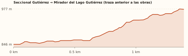
Elevation

Trail profile

Elevation profile: Gutiérrez ranger station → Viewpoint (route before the works)

Gutiérrez ranger station → Viewpoint (route before the works)

Length
1.4 km
Elevations
846 → 976 m
Elevation gain
+146 m (180 m according to Bariloche Trekking)
Uphill
≈45 min – 1 h
Downhill
≈35 – 45 min
Difficulty
Moderate; hard from May to October

This is the profile of the previous route: National Parks is building a new one that is not yet on OpenStreetMap. From Villa Los Coihues, add 3 km along the shore. Times calculated at an easy pace, without stops.

Location and directions

How to get there

You arrive at: Lake Gutiérrez ranger station. The trail starts opposite the ranger station, next to the Lago Gutiérrez campground (the same start as Cascada de los Duendes).

Car, taxi or remis

16.1 km · about 26 min (the last 2.2 km on gravel)

Where to park: Next to the ranger station
Free parking. View on Google Maps
Don't leave valuables in sight.
  1. Take Route 82 to Villa Los Coihues.
  2. Cross the entrance bridge and continue on the shore road to the ranger station.
Open this route in Google Maps
Ratings from 1 to 5

What it's like, in numbers

How crowded is it?3/5
Very few peopleVery crowded

Moderately busy. It used to be one of the most used trails at the ranger station. To be checked

How physically demanding is it?3/5
Very easyVery hard

Slopes or uneven ground. Short but steep.

How much nature is there?5/5
Very littleA lot

Pure nature. National Park forest.

Does it work on a windy day?3/5
Very exposedVery sheltered

Some shelter. Forest on the way up, exposed viewpoint. To be checked

Is it easy to get there without a car?3/5
HardVery easy

Bus + 1–3 km walk. Bus plus a 3 km walk.

Are there facilities?3/5
NoneFull

Some. New toilets and a campground at the start; nothing on the trail.

Is it good with kids?2/5
Not recommendedIdeal

Older kids only. Older kids only, with good shoes.

In 10 seconds

What you want to know

Does it cost money?

Free!

We found no fee at the ranger station. Trekking registration is mandatory and free.

  • EntranceARS 0We found no fee at this National Park entrance. To be checked
  • Trekking registrationFree and mandatoryAccording to Bariloche Trekking. In October 2026 National Parks fined a tourist who got injured on a nearby trail without registering.
  • ParkingARS 0Next to the ranger station.
  • Bus (one way)ARS 2,333.30With a SUBE card. Standard fare for sections I to III; residents with a registered SUBE card ARS 1,749.98 (since 30/07/2026).

Can I bring my dog?

Not allowed

Leave your dog at home: it is a National Park.

What the rules say

It is inside Nahuel Huapi National Park (measured with the official boundaries on OpenStreetMap), where pets are not allowed, except guide dogs.

What happens in practice

In February 2026 National Parks issued another warning about pets entering the park, after a dog bit a ranger (ANBariloche).

Context

Pets are not allowed in Nahuel Huapi National Park or in Llao Llao Municipal Park (guide dogs only).

What's the easiest way to get there?
By car

No bus nearby: the closest stop is 3 km away.

How long does it take?
2 h 30 to 3 h 30

Walking 1 h 30 a 2 h 30 + 26 min by car each way.

Are there toilets or food?
Yes

At the ranger station (new block, Jun. 2026). Campground store in season.

When is the best time?
Closed for works

National Parks closed the trail on 20/04/2026 to build a new route with steps and expects to reopen it in late November 2026. As of 17/11 there was still no reopening announcement: don't go in while it is closed.

What people say

Reviews

What media, guides and visitors say
Media, guides and forums

“Although it is a short trail, it has a steep slope and considerable difficulty.”

Parques Nacionales, jul. 2026
Media, guides and forums

“The last part is quite steep: watch out for roots so you don't trip.”

Bariloche Trekking
All reviews and photosOpen Lake Gutiérrez Viewpoint in Google Maps

If you like this place…

Fact sheet

Type
Viewpoints · Hiking and walks
Activities
Short climb · Viewpoint · National Park forest
Area
Lake Gutiérrez · Villa Los Coihues
Location
Lake Gutiérrez ranger station, past Villa Los Coihues along the shore road
Distance from the Civic Center
16.1 km · 26 min by car · 3 h 28 on foot
Time walking
1 h 30 a 2 h 30 (round trip from the ranger station)
Whole outing by car
2 h 30 to 3 h 30
Trail length
≈1.4 km uphill (≈2.8 km round trip)
Route type
Out and back
Elevation gain
+150 a 180 m
Elevation
≈846 m s.n.m. · max. ≈976 m s.n.m.
Difficulty
Moderate: steep at the end
Terrain
Dirt with roots; steps on the new route
Signposting
Signposted from the ranger station
Water on the way
Pescadero stream, at the start
Nearby bus lines
41, 50 (stop 3 km away)
Gravel road
Yes, on the last stretch
Toilets
Yes · At the ranger station (new block, Jun. 2026)
Food
Yes · Campground store in season
Lifeguards
No · Not applicable
Shade
Yes · Forest on the way up
Phone signal
Yes · Unconfirmed
Best months
Nov, Dec, Jan, Feb, Mar, Apr
Dogs
Not allowed
Cost
Free
Data checked on
November 18, 2026

What to bring

  • Shoes with good grip
  • Water
  • A windbreaker for the viewpoint

Tips

  • Before you go, check with National Parks whether it has reopened.
  • Add Cascada de los Duendes: it shares the start.

Safety

  • Steep slope and roots: there have been many evacuations for injuries.
  • Don't go in while it is closed: respect the signs.
Sources for this page (7)

Most sources are in Spanish.

Photos: Luca Ezequiel Rodríguez (CC BY-SA 4.0), bullit (CC BY 3.0), CarlosJBJ (CC BY-SA 4.0), bullit (CC BY 3.0), Alexrebolledo (CC BY-SA 3.0), via Wikimedia Commons.