All places

Refugio López (Cerro López)

The hut with the best view of Nahuel Huapi: only 4 km but 730 m of climbing from Circuito Chico

Great for

A huge view for little distance

Brazo Tristeza and Nahuel Huapi at your feet.

Going without a car

Bus 10 stops at the trailhead.

Your first hut to sleep in

Short, with food and room for 100.

A day of steep climbing

730 m in 4 km.

Not for: Bringing a dog: it's a National Park · People with knee problems: the descent is very steep · July to December without crampons

The experience

What to do there

Refugio Carlos Sonntag, known as Refugio López, is privately managed and looks straight out over Brazo Tristeza and the Circuito Chico lakes. It is one of Bariloche's most accessible huts: bus 10 drops you at the trailhead.

The climb is short but relentless, with no flat sections. After an hour you reach Roca Negra, a natural viewpoint, and then the hut. From there, with experience, you can continue to Pico Turista and the summit of López.

Sleeping in the mountains

The hut: booking, food and facilities

Booking

Check with the hut before going up to sleep.

Capacity

About 100 people and a camping area (Diario Río Negro).

Food

Dinner, breakfast and drinks.

Management

Private: it isn't run by the Club Andino.

Watch out

You have to ford the López stream: there's no bridge.

Contact

refugiolopez.com.ar

Reference prices from December 2025; we couldn't find this season's.
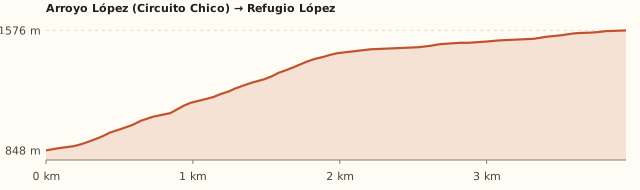
Elevation

Trail profile

Elevation profile: López stream (Circuito Chico) → Refugio López

López stream (Circuito Chico) → Refugio López

Length
4.0 km
Elevations
850 → 1.580 m
Elevation gain
+730 m
Uphill
≈2 h 50
Downhill
≈1 h 50
Difficulty
Moderate: a hard, sustained climb
  1. It starts at the López stream, on Circuito Chico.
  2. It climbs relentlessly through the forest and then up the open slope.
  3. After an hour you pass Roca Negra, a good rest spot with a view; the hut appears above.

Measured on OpenStreetMap trails. Bariloche Trekking gives 4 km and 3 h up; Diario Río Negro, 4.5 km, 820 m and 3 to 4 h. Times calculated at an easy pace, without stops.

Location and directions

How to get there

You arrive at: Trailhead at the López stream (Circuito Chico). On Circuito Chico, at the López stream, past Bahía López towards Colonia Suiza.

Car, taxi or remis

25 km · about 35 min

Where to park: Circuito Chico verge, by the López stream To be checked
Limited space along the roadside. View on Google Maps
Don't leave anything in sight.
  1. Take Bustillo to km 18 and continue along Circuito Chico, past Llao Llao and Bahía López.
  2. Shortly after Bahía López you cross the López stream: that's where the trail starts.
Open this route in Google Maps
Ratings from 1 to 5

What it's like, in numbers

How crowded is it?3/5
Very few peopleVery crowded

Moderately busy. Very popular because it's short and has a bus.

How physically demanding is it?4/5
Very easyVery hard

Several hours or a lot of climbing. Short but very steep: 730 m in 4 km.

How much nature is there?4/5
Very littleA lot

Mostly natural. Forest and mountainside, with the road below.

Does it work on a windy day?2/5
Very exposedVery sheltered

Exposed. The slope is exposed to the west. To be checked

Is it easy to get there without a car?5/5
HardVery easy

Several bus lines at the door. Bus 10 stops at the trailhead.

Are there facilities?3/5
NoneFull

Some. Hut with food and beds.

Is it good with kids?2/5
Not recommendedIdeal

Older kids only. For older kids: the slope is steep. To be checked

In 10 seconds

What you want to know

Does it cost money?

Free!

Hiking up is free. In December 2025 a bed cost ARS 50,000 and camping ARS 15,000; residents get 15 to 20% off.

  • EntranceARS 0No access fee.
  • Overnight stay≈ARS 50,000December 2025 price: check this season's. To be checked
  • Camping≈ARS 15,000December 2025. To be checked
  • Dinner / breakfastARS 30,000 a ARS 45,000 / ARS 20,000December 2025. To be checked
  • Resident discount15 a 20 %According to Diario Río Negro.
  • Bus 10 (one way)Higher fare sectionWith a SUBE card. Because of the distance, a higher fare section may apply (section IV: ARS 3,383.32): check when you board.

Can I bring my dog?

Not allowed

Leave your dog at home: it's a National Park and the hut won't take it.

What the rules say

The trail and the hut are inside Nahuel Huapi National Park (measured against the official boundaries in OpenStreetMap), where pets are not allowed, except guide dogs.

What happens in practice

Club Andino huts don't accept pets either. In February 2026 the National Parks again warned about people bringing dogs in, after one bit a park ranger (ANBariloche).

Context

Pets are not allowed in Nahuel Huapi National Park or in Llao Llao Municipal Park (guide dogs only).

What's the easiest way to get there?
Bus or car

Lines 10. Get off 100 m away.

How long does it take?
6 h 30 to a full day

Round-trip hike 5 a 7 h + 36 min by car each way.

Do I need to book?
Best to check

We couldn't find a published booking system: contact the hut before going up to sleep.

Can I do it as a day trip?
Yes, in 5 to 7 h

It's the shortest hut hike in Bariloche: about 3 h up and 2 h down.

Are there toilets or food?
Yes

At the hut. At the hut: dinner, breakfast and drinks.

When is the best time?
Better at another time of year

From January to March it's moderate (Bariloche Trekking). From July to December there may be snow and you need crampons.

What people say

Reviews

What media, guides and visitors say
Media, guides and forums

“It's one of the most accessible huts in Bariloche: 4.5 km and 3 to 4 h up.”

Diario Río Negro
Media, guides and forums

“Moderate from January to March; from July to December you need crampons.”

Bariloche Trekking
All reviews and photosOpen Refugio López (Cerro López) in Google Maps

If you like this place…

Fact sheet

Type
Mountain huts · Hiking and walks · Viewpoints
Activities
Steep climb · Overnight in a mountain hut · Camping · Viewpoint
Area
Cerro López · Circuito Chico
Location
On the slope of Cerro López, at about 1,600 m, above Brazo Tristeza
Distance from the Civic Center
25 km · 36 min by car
Time round-trip hike
5 a 7 h (about 3 h up and 2 h down)
Whole outing by car
6 h 30 to a full day
Trail length
≈4 km up (8 km round trip)
Route type
Out and back
Elevation gain
≈+730 m
Elevation
≈850 m at the López stream · max. ≈1,580–1,620 m at the hut
Difficulty
Moderate: short but very steep
Terrain
Dirt track and a steep trail with loose rock
Signposting
It starts at the López stream, on Circuito Chico
Water on the way
You have to ford the López stream (there's no bridge); bring water
Nearby bus lines
10 (stop 100 m away)
Gravel road
No, paved all the way
Toilets
Yes · At the hut
Food
Yes · At the hut: dinner, breakfast and drinks
Lifeguards
No · Not applicable
Shade
Yes · Forest in the first part; exposed up top
Phone signal
Yes · There's usually signal on the slope, facing Bariloche
Best months
Jan, Feb, Mar
Dogs
Not allowed
Cost
Free to hike up
Data checked on
November 19, 2026

What to bring

  • Trekking poles: the descent punishes your knees
  • Water (1.5 litres)
  • Windbreaker
  • Cash for the hut
  • Crampons from July to December

Tips

  • Go down slowly: the slope is constant and loose rock is slippery.
  • Combine it with Bahía López on the way down.
  • Check the return times for bus 10.

Safety

  • Log your hike in the National Park trekking registration.
  • Don't continue to the summit of López without experience: there are exposed rock steps.
  • There is another route from Bahía López, for experts only: 11 km, 1,300 m and 8 to 9 h (Bariloche Trekking).
Sources for this page (6)

Most sources are in Spanish.

Photos: MMLDND (CC BY-SA 4.0), MMLDND (CC BY-SA 4.0), Estany3 (CC BY-SA 3.0), Estany3 (CC BY-SA 3.0), Limonada (CC BY-SA 2.5), via Wikimedia Commons.