All places

Refugio San Martín (Laguna Jakob)

A blue lake at 1,550 m at the end of the Casa de Piedra stream valley: 13 km of forest from Tambo de Báez

Great for

Spending a night in the mountains

Bed or camping, with dinner and breakfast.

A long hike with no technical difficulties

Marked trail, with water along the way.

Laguna Témpanos

30 min from the hut, with floating ice in early summer.

Starting a traverse

Jakob – Laguna Negra or Jakob – Los Césares, for experienced hikers.

Not for: A day trip without good fitness · Bringing a dog: it's a National Park · Kids who can't walk for many hours

The experience

What to do there

A Club Andino hut on the shore of a turquoise lake, surrounded by peaks with patches of snow well into summer. Reopened in 2018, it replaced the stone-and-wood hut from 1952.

The trail follows the Casa de Piedra stream valley through the forest and ends with a zigzag climb. Half an hour from the hut is Laguna Témpanos, which has floating ice in early summer. Traverses to Laguna Negra and Los Césares start from Jakob, for experienced hikers only.

Sleeping in the mountains

The hut: booking, food and facilities

Booking

Bookings are required, also for Club Andino members. Deposits are non-refundable; you can change the date up to 48 h before. Bring your receipt.

Capacity

About 70 places and a camping area (Argentina Trekking).

Food

Dinner, breakfast and packed lunches: arranged on arrival.

Open

All year.

Water

From the stream, all along the way.

Nearby

Laguna Témpanos, 30 minutes away.

Contact

refugiojakob.com.ar · refugiojakob@gmail.com

Rates in force from 1/12/2026 according to the hut.
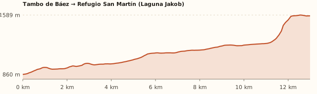
Elevation

Trail profile

Elevation profile: Tambo de Báez → Refugio San Martín

Tambo de Báez → Refugio San Martín

Length
13.0 km
Elevations
860 → 1.580 m
Elevation gain
+790 m
Uphill
≈5 h 20
Downhill
≈4 h
Difficulty
Moderate
  1. It starts at Tambo de Báez, at the end of the Casa de Piedra stream road (RP 79).
  2. It follows the stream valley through the forest, with gentle climbs and bridge crossings, for about 10 km.
  3. At the end of the valley it zigzags up through lenga forest to the lake.

Measured on OpenStreetMap trails. Bariloche Trekking gives 14 km, 800 m of elevation gain and 5 to 6 h; Argentina Trekking, 13 km and 4 to 6 h. Times calculated at an easy pace, without stops.

Location and directions

How to get there

You arrive at: Tambo de Báez (trailhead). At the end of the Casa de Piedra stream gravel road (RP 79), past the white bridge. That's where the trail begins.

Car, taxi or remis

16.2 km · about 23 min to Tambo de Báez

Where to park: Tambo de Báez car park To be checked
Private land with paid parking at the trailhead. View on Google Maps
You'll leave the car for one or two nights: don't leave anything in sight.
  1. Take Bustillo to km 10.5 (Puerto Moreno) and turn left onto Ruta 79.
  2. Follow RP 79, a gravel road, past the white bridge over the Casa de Piedra stream.
  3. One kilometre further on is Tambo de Báez, where the trail starts.
Open this route in Google Maps
Ratings from 1 to 5

What it's like, in numbers

How crowded is it?3/5
Very few peopleVery crowded

Moderately busy. Very popular in summer, but quieter than Frey. To be checked

How physically demanding is it?4/5
Very easyVery hard

Several hours or a lot of climbing. 13 km one way and about 800 m of elevation gain.

How much nature is there?5/5
Very littleA lot

Pure nature. Valley of native forest, stream and alpine lake.

Does it work on a windy day?3/5
Very exposedVery sheltered

Some shelter. The valley gives shelter; at the lake, exposed. To be checked

Is it easy to get there without a car?2/5
HardVery easy

Car yes, bus stop far away. The bus drops you about 5.5 km from the trailhead.

Are there facilities?3/5
NoneFull

Some. Hut with food and beds; nothing along the way.

Is it good with kids?2/5
Not recommendedIdeal

Older kids only. For older kids who like walking, ideally sleeping up there. To be checked

In 10 seconds

What you want to know

Does it cost money?

Free!

Hiking up is free (parking at Tambo de Báez is paid). A bed costs ARS 60,000 and camping ARS 12,000 per person (hut, from 1/12/2026).

  • EntranceARS 0There is no Park access fee in this sector.
  • Parking at Tambo de BáezPaymentIt's private land at the trailhead; we couldn't find the rate. To be checked
  • Bed for the nightARS 60,000Per person. Rates from 1/12/2026.
  • CampingARS 12,000Per person.
  • Half board / full boardARS 150,000 / ARS 170,000Dinner ARS 60,000 · breakfast ARS 30,000 to ARS 40,000 · packed lunch ARS 40,000.
  • Discounts10 % y 50 %10% for residents, students and retirees; 50% for under-10s.
  • Bus (one way)ARS 2,333.30With a SUBE card. Standard fare for sections I to III; residents with a registered SUBE pay ARS 1,749.98 (since 30/07/2026).

Can I bring my dog?

Not allowed

Leave your dog at home: it's a National Park and the hut won't take it.

What the rules say

The trail and the hut are inside Nahuel Huapi National Park (measured against the official boundaries in OpenStreetMap), where pets are not allowed, except guide dogs.

What happens in practice

Club Andino huts don't accept pets either. In February 2026 the National Parks again warned about people bringing dogs in, after one bit a park ranger (ANBariloche).

Context

Pets are not allowed in Nahuel Huapi National Park or in Llao Llao Municipal Park (guide dogs only).

What's the easiest way to get there?
By car

No bus nearby: the closest stop is 5.6 km away.

How long does it take?
10 h to a full day

Round-trip hike 9 to 11 h, or 2 days + 23 min by car each way.

Do I need to book?
Yes, to sleep

The hut works with bookings; changes up to 48 h before.

Can I do it as a day trip?
You can, but it's long

26 km round trip: 9 to 11 h of walking. Most people sleep up there.

Are there toilets or food?
Yes

At the hut. At the hut: dinner, breakfast and packed lunches (arranged on arrival).

When is the best time?
Better at another time of year

December to April without snow. The hut is open all year; in winter the climb is on snow.

What people say

Reviews

What media, guides and visitors say
Media, guides and forums

“The hut is open all year and works with bookings; members must book too.”

Club Andino Bariloche
Media, guides and forums

“About 13 km and 4 to 6 hours one way.”

Argentina Trekking
All reviews and photosOpen Refugio San Martín (Laguna Jakob) in Google Maps

If you like this place…

Fact sheet

Type
Mountain huts · Hiking and walks
Activities
Full-day hike · Overnight in a mountain hut · Camping · Laguna Témpanos · Traverses
Area
Casa de Piedra valley · Nahuel Huapi National Park
Location
On the shore of Laguna Jakob, at 1,564 m, at the end of the Casa de Piedra stream valley
Distance from the Civic Center
16.2 km · 23 min by car
Time round-trip hike
9 to 11 h, or 2 days (5 to 6 h up and about 4 h down; most people sleep up there)
Whole outing by car
10 h to a full day
Trail length
≈13 km one way (26 km round trip)
Route type
Out and back through the same valley
Elevation gain
≈+800 m
Elevation
≈860 m at Tambo de Báez · max. ≈1,580 m at the hut
Difficulty
Moderate: long, with a hard final climb
Terrain
Dirt trail through the forest, with roots; steep zigzags at the end
Signposting
Marked and well-used trail (part of the Huella Andina)
Water on the way
The trail follows the stream: there's water almost all the way
Nearby bus lines
10, 20, 21, 51 (stop 5.6 km away)
Gravel road
Yes, on the last stretch
Toilets
Yes · At the hut
Food
Yes · At the hut: dinner, breakfast and packed lunches (arranged on arrival)
Lifeguards
No · Not applicable
Shade
Yes · Forest almost all the way
Phone signal
No · No signal in the valley
Best months
Dec, Jan, Feb, Mar, Apr
Dogs
Not allowed
Cost
Free to hike up
Data checked on
November 19, 2026

What to bring

  • Hiking boots
  • Rain jacket and warm layers
  • Food for the day
  • Cash for the hut
  • Sleeping bag if you stay
  • Booking receipt

Tips

  • Start early: the valley is long.
  • If you go by bus, add 1 h 15 of gravel road each way or share a remis to Tambo de Báez.
  • Visit Laguna Témpanos in the afternoon or the next morning.

Safety

  • Log your hike in the National Park trekking registration.
  • The Jakob – Laguna Negra and Jakob – Los Césares traverses cross high passes: only with experience, good weather and a GPS track.
  • In the rain, the roots and rocks in the valley get slippery.
Sources for this page (8)

Most sources are in Spanish.

Photos: McKay Savage (CC BY 2.0), McKay Savage (CC BY 2.0), McKay Savage (CC BY 2.0), McKay Savage (CC BY 2.0), McKay Savage (CC BY 2.0), Estefania Chereguini Cabezas Estefania Chereguini Cabezas (CC BY 3.0), via Wikimedia Commons.