All places

Refugio Frey (Cerro Catedral)

Bariloche's most famous mountain hut: granite spires, Laguna Toncek and a climb of about 4 hours from Villa Catedral

Great for

Your first mountain hut

A marked, busy trail with a bus to the trailhead.

Sleeping up high and watching the sunrise

Bed, dinner and breakfast, or free camping with a booking.

A full day of hiking

About 7 to 9 h round trip, not counting time at the top.

Climbers

It is the base for the Catedral spires.

Going without a car

Bus 55 drops you at the trailhead.

Not for: Bringing a dog: it's a National Park · Small children or people not used to walking · Rainy days or whiteout conditions up top · Going up in winter without snow gear

The experience

What to do there

A stone hut of the Club Andino Bariloche on the shore of Laguna Toncek, beneath the towers and spires of Catedral, Patagonia's classic rock-climbing spot. From the rocks by the hut you can see the whole valley and, on clear days, Mount Tronador.

You hike in from the base of Cerro Catedral, served by bus 55: about 10 km through the forest, almost flat at first, with a steep climb at the end up the Van Titter valley. Some people go up and back in a day; others sleep up there to see sunset and sunrise on the spires.

Sleeping in the mountains

The hut: booking, food and facilities

Booking

Required to sleep or camp. Bookings are only taken for the next 7 days, with a 50% deposit; the rest is paid up top, in cash.

Capacity

35 beds in bunks and a camping area.

Food

Breakfasts, dinners and packed lunches for the day, with vegetarian and vegan options.

Open

All year. In winter, with snow.

Payment

Cash up top: there's no signal for transfers.

What there isn't

No kitchen for guests and no showers. Fires are not allowed.

Club Andino members

They get a discount on beds and food.

Contact

refugiofreybariloche.com (bookings and rates).

Hut rates for December 2026. They change every season: confirm when you book.
Elevation

Trail profile

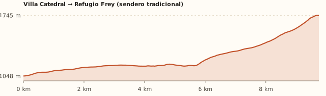
Elevation profile: Villa Catedral → Refugio Frey (classic trail)

Villa Catedral → Refugio Frey (classic trail)

Length
9.8 km
Elevations
1.050 → 1.745 m
Elevation gain
+740 m
Uphill
≈4 h 20
Downhill
≈3 h 10
Difficulty
Moderate
  1. It starts at the car park at the base of Catedral, where the hut's sign is. The first 300 m follow a vehicle track to the turn-off onto the trail.
  2. It contours the mountain through the forest, almost flat, for about 6 km.
  3. It enters the Van Titter stream valley and climbs hard for the last hour and a half, among rocks, up to Laguna Toncek.

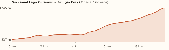
Lago Gutiérrez ranger station → Refugio Frey (Picada Eslovena)

Length
9.7 km
Elevations
840 → 1.745 m
Elevation gain
+955 m
Uphill
≈4 h 50
Downhill
≈3 h 30
Difficulty
Moderate to hard: steeper
  1. It starts at the Lake Gutiérrez ranger station, in Villa Los Coihues.
  2. It climbs through the Cerro Catedral forest (the Picada Eslovena) and joins the classic trail in the Van Titter valley.
  3. The Club Andino rates it as harder than the route from Villa Catedral.
Elevation profile: Lago Gutiérrez ranger station → Refugio Frey (Picada Eslovena)

Punta Princesa (Catedral ridge) → Refugio Frey

Length
≈6 km
Elevations
Along the ridge, above 2,000 m
Elevation gain
≈+320 m and steep descents
Uphill
4 a 5 h
Downhill
—
Difficulty
Hard: experienced hikers only
  1. You reach the ridge using the Catedral lifts (check whether they run in summer).
  2. It follows the ridge, with rocky steps and loose stones, then drops down to the hut. Bariloche Trekking rates it hard.

We measured the first two routes on OpenStreetMap trails. The hut estimates 4 h up and 2 h 30 down in summer, and up to 6 h with snow; the Club Andino, 4 to 6 h and 10 km with 700 m of elevation gain; Bariloche Trekking, 4 to 5 h. Times calculated at an easy pace, without stops.

Location and directions

How to get there

You arrive at: Base of Cerro Catedral (Refugio Frey sign). In the ski resort base car park there is a sign with the hut's name. The first 300 m follow a vehicle track to the turn-off onto the trail (Club Andino).

Car, taxi or remis

19.4 km · about 25 min to the base of Catedral

Where to park: Car park at the base of Catedral To be checked
In summer there is usually space in the base car parks. View on Google Maps
You'll leave the car all day or overnight: don't leave anything in sight.
  1. Take Bustillo to km 8.5 and turn left onto Av. de los Pioneros / Ruta 82 towards Cerro Catedral.
  2. Follow the signs to Villa Catedral up to the ski resort base.
  3. Park and look for the Refugio Frey sign next to the car park.
Open this route in Google Maps
Ratings from 1 to 5

What it's like, in numbers

How crowded is it?4/5
Very few peopleVery crowded

Busy in high season. It's the most visited hut: in January and February the trail is busy and the campsite fills up.

How physically demanding is it?4/5
Very easyVery hard

Several hours or a lot of climbing. 10 km one way and about 750 m of elevation gain, with a steep last hour.

How much nature is there?5/5
Very littleA lot

Pure nature. Forest, glacial valley, alpine lake and granite spires.

Does it work on a windy day?2/5
Very exposedVery sheltered

Exposed. The valley offers some shelter, but it blows hard up top. To be checked

Is it easy to get there without a car?4/5
HardVery easy

Bus stop under 300 m away. Bus 55 to the base of Catedral.

Are there facilities?3/5
NoneFull

Some. Hut with food, toilets and beds; nothing along the way.

Is it good with kids?2/5
Not recommendedIdeal

Older kids only. For older kids who can walk well for several hours. To be checked

In 10 seconds

What you want to know

Does it cost money?

Free!

Hiking up is free. A bed costs ARS 80,000 per person and half board ARS 152,000; camping is free with a booking (hut, Dec. 2026).

  • EntranceARS 0There is no access fee in this part of the National Park.
  • Bed for the nightARS 80,000Per person per night (hut rates, Dec. 2026).
  • Half board (dinner + bed + breakfast)ARS 152,000Full board with packed lunch: ARS 185,000 (Dec. 2026).
  • Individual mealsDinner ARS 35,000Breakfast ARS 25,000 · packed lunch ARS 35,000 (Dec. 2026).
  • Sleeping bag rentalARS 20,000If you don't bring your own.
  • CampingARS 0Free, but you must book ahead (hut).
  • Bus 55 (one way)Higher fare sectionWith a SUBE card. Because of the distance, a higher fare section may apply (section IV: ARS 3,383.32): check when you board.

Can I bring my dog?

Not allowed

Leave your dog at home: it's a National Park and the hut won't take it.

What the rules say

The trail and the hut are inside Nahuel Huapi National Park (measured against the official boundaries in OpenStreetMap), where pets are not allowed, except guide dogs.

What happens in practice

Club Andino huts don't accept pets either. In February 2026 the National Parks again warned about people bringing dogs in, after one bit a park ranger (ANBariloche).

Context

Pets are not allowed in Nahuel Huapi National Park or in Llao Llao Municipal Park (guide dogs only).

What's the easiest way to get there?
Bus or car

Lines 55. Get off 300 m away.

How long does it take?
8 h to a full day

Round-trip hike 7 to 9 h, or 2 days + 25 min by car each way.

Do I need to book?
Yes, to sleep or camp

With a 50% deposit and no more than 7 days ahead. For a day trip you don't need to book.

Can I do it as a day trip?
Yes, in 8 to 9 h

Start early: about 4 h up, some time at the top and 2 h 30 to 3 h down.

Are there toilets or food?
Yes

At the hut. At the hut: breakfasts, dinners and packed lunches (cash payment).

When is the best time?
Better at another time of year

December to April, with no snow on the trail (Club Andino). The hut is open all year, but in winter the climb is on snow and you need gear and experience.

What people say

Reviews

What media, guides and visitors say
Media, guides and forums

“The hut estimates about 4 hours up and 2 hours 30 down in summer.”

Refugio Frey, cómo llegar
Media, guides and forums

“Easy to moderate from December to April: 10 km, 700 m of elevation gain and 4 to 6 hours of walking.”

Club Andino Bariloche
All reviews and photosOpen Refugio Frey (Cerro Catedral) in Google Maps

If you like this place…

Fact sheet

Type
Mountain huts · Hiking and walks
Activities
Full-day hike · Overnight in a mountain hut · Camping · Rock climbing · Alpine lake
Area
Cerro Catedral · Nahuel Huapi National Park
Location
At the foot of the Frey spire, on the shore of Laguna Toncek, at 1,700 m
Distance from the Civic Center
19.4 km · 25 min by car
Time round-trip hike
7 to 9 h, or 2 days (about 4 h up and 2 h 30 to 3 h down; many people sleep up there)
Whole outing by car
8 h to a full day
Trail length
≈10 km one way (20 km round trip)
Route type
Out and back, or up from Villa Catedral and down the Picada Eslovena to Los Coihues
Elevation gain
≈+750 m from Villa Catedral · ≈+950 m via the Picada Eslovena
Elevation
≈1,050 m at the base of Catedral · max. ≈1,700–1,745 m at the hut
Difficulty
Moderate: long, with a steep final climb
Terrain
Dirt road at first; then a dirt and stone trail; the end is loose rock and boulders
Signposting
Sign at the base of Catedral and paint marks on the final stretch
Water on the way
There are streams along the way; carry at least 1 litre
Nearby bus lines
55 (stop 300 m away)
Gravel road
No, paved all the way
Toilets
Yes · At the hut
Food
Yes · At the hut: breakfasts, dinners and packed lunches (cash payment)
Lifeguards
No · Not applicable
Shade
Yes · Forest for much of the way; exposed up top
Phone signal
No · Little or none in the valley
Best months
Dec, Jan, Feb, Mar, Apr
Dogs
Not allowed
Cost
Free to hike up
Data checked on
November 19, 2026

What to bring

  • Hiking boots with good soles
  • Windbreaker and rain jacket even if it's sunny
  • Warm layers for up top: it gets cold in the afternoon
  • Water (1 litre) and food for the day
  • Cash for the hut
  • Sleeping bag if you stay (or rent one)
  • Headlamp

Tips

  • Start before 9 am if you're doing it as a day trip.
  • To sleep there, book as soon as your week opens: it fills up in January.
  • You can go up from Villa Catedral and down the Picada Eslovena to Los Coihues: arrange your return.
  • Check the mountain forecast: the weather on Catedral changes fast.

Safety

  • Log your hike in the National Park trekking registration.
  • Don't leave the trail on the rocky section: it's easy to twist an ankle.
  • With snow or bad weather, the last stretch becomes dangerous: turn back.
  • If night falls, use your headlamp and don't look for shortcuts.
Sources for this page (10)

Most sources are in Spanish.

Photos: Justraveling.com (CC BY-SA 4.0), Alejandroravignani (CC BY-SA 4.0), McKay Savage (CC BY 2.0), Gabo2012 (CC BY-SA 3.0), McKay Savage (CC BY 2.0), Fernando Lopez Anido (CC0), via Wikimedia Commons.