“People recommend it as a short family outing, but not for older adults, with care for kids and avoiding days after heavy rain or snow.”
Fishing season open until April 1
Casa de Piedra Stream Trail
A short forest walk along the stream to El Cajón and a natural viewpoint
Great for
≈3 km round trip, in 1 to 2 h.
There are rocky spots right by the water.
You walk along the bottom of a ravine, inside the forest.
The stream squeezed between two huge rocks.
According to local guides, the forest changes color in autumn.
Not for: Watching the sunset: it is a closed, forested valley · Older people or anyone with limited mobility
What to do there
A short and very natural walk on the old road to Colonia Suiza. It starts at a white bridge and follows the Casa de Piedra stream inside the forest, with short climbs, logs and stretches of loose dirt.
After about 700 m you reach El Cajón, where the water runs between two huge boulders, and then a natural viewpoint over the valley. Most people turn back there. If you want more, you can close a loop via Tambo Báez.
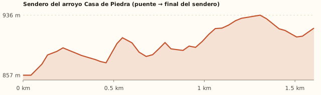
Trail profile
White bridge → end of the trail
- Length
- 1.6 km
- Elevations
- 857 → 919 m (max. 936 m)
- Elevation gain
- +147 / −85 m
- Out
- ≈50 min
- Back
- ≈45 min
- Difficulty
- Moderate: short but with slopes
Measured on the OpenStreetMap track with a 90 m terrain model. Times calculated at an easy pace, without stops.
How to get there
Car, taxi or remis
14.7 km · about 20 min (the last 4 km on gravel)
- Take Av. San Martín west and at the roundabout continue on Av. Bustillo.
- Drive 9.6 km along Bustillo to km 10.5 (Puerto Moreno). Landmark: the “Bustillo 10500 – Puerto Moreno” bus stop.
- Turn left onto Provincial Route 79 (old road to Colonia Suiza). After 200 m you pass the “Ruta 79 y Zorzales” stop: you are on the right track.
- Continue uphill for 1.4 km. Where the road bends west, keep going on RP 79 “Napoleón Beveraggi” for about 2.8 km of gravel.
- You reach a white bridge over the Casa de Piedra stream. Park just before the bridge, on the shoulder.
- If you reach the junction with the Tambo Báez turnoff, 1 km after the bridge, you have gone too far.
- Taxi or remis: ask for “Ruta 79, puente del arroyo Casa de Piedra (camino viejo a Colonia Suiza)” and show the driver the spot on the map. Arrange your ride back before the driver leaves: no taxis pass by there.
Bus + walk
Doesn't reach the bridge · bus to km 10.5 + 4.5 km on foot (1 h 05)
- No bus goes past the bridge. The closest is Av. Bustillo.
- Take line 10, 20, 21 or 51 and get off at “Bustillo 10500 – Puerto Moreno”.
- Walk along RP 79 for about 4.5 km (≈1 h 05) to the bridge. It is uphill, on gravel and shared with cars: walk facing the traffic.
- Total one way: 1 h 45 to 2 h from downtown. Bring extra water.
- Payment: SUBE card only. Standard fare ARS 2,333.30; residents with a registered SUBE card ARS 1,749.98.
By bike
14.7 km · the last 4 km uphill on gravel
- Along Bustillo to km 10.5 and then uphill on RP 79. With a mountain bike it makes a nice combination.
- Lock your bike near the bridge, visible from the road: the trail is narrow and full of logs, not suitable for biking.
Fishing: rules and tips
Fishing season open until April 1
- What you can catch
Rainbow and brown trout
- Methods
Fly fishing only
- What you can keep
Nothing: release every fish, including perch and silverside.
- Season
Season from November 1 to April 1
- Hours
Daylight only: from sunrise to sunset (Río Negro). In mid-November, ≈06:20 to 20:40; in January, ≈06:30 to 21:20.
- Where from
From the Ruta 79 bridge (the one on the trail) to its mouth in Lake Moreno, at Playa del Viento.
- Lures and flies that work
Nymphs and small dry flies: it is a fly-fishing stream.
- Best time
At the start of the season and at sunset.
- Jurisdiction
Río Negro
Rules for this spot
- Season from 01/11/2026 to 01/04/2027: it closes a month earlier than the rest.
- Fly only and mandatory catch-and-release, barbless hook.
- Artificial lures only, with a single hook and one rod per person: bait is banned.
- Perch, silverside, puyén and Atlantic salmon must always be released.
- Felt-soled wading boots and lead weights are banned.
- Didymo: before moving to another river or lake, disinfect your gear (30 min in 10 litres of water with 200 ml of bleach) or let it dry for 48 h.
Watch out
- Upstream of the bridge, along the trail, the regulations say nothing: ask the fishing wardens (0800-777-3722).
Licence
Required. One licence covers Río Negro, Neuquén, Chubut and the National Parks. Foreign visitors: ARS 50,000 a day, ARS 140,000 for 10 days, ARS 280,000 for the season (Argentines: ARS 12,500 / 25,000 / 50,000). Carry it with your ID. Wardens: 0800-777-3722.
Get the licencePatagonian Freshwater Fishing Regulations 2026/27. Rules change every season: check them before you go.
What it's like, in numbers
Few people. A little-known trail away from the tourist circuits. Mostly locals walk it; on nice weekends there are a few more people.
Slopes or uneven ground. Short (3 km), but with a steep climb, loose-dirt descents, logs and slippery parts. The local guide rates it as moderate.
Pure nature. Native forest and a mountain stream: as soon as you leave the bridge you see no buildings. On the loop, the way back is along a gravel road.
Sheltered. You walk inside the forest at the bottom of a ravine: a good plan for windy days. To be checked
Car yes, bus stop far away. Easy by car (last stretch on gravel). There is no bus nearby: the closest stop is about 4.5 km away, uphill.
None. Nothing: no toilets, no drinking water, no shops. There is stream water, but treat it.
Older kids only. For kids who already walk well, with supervision: there are steep banks and logs. The local guide asks for care with children and does not recommend it for older people.
What you want to know
Does it cost money?
There is no entrance fee and, since it lies outside the National Park, no trekking registration is needed. If you continue to Laguna Jakob you do need it: registration is mandatory and free.
- EntranceARS 0No source mentions a fee or an access control.
- Trekking registrationNot neededAccording to the OpenStreetMap boundaries, the trail is outside the National Park. To continue to Laguna Jakob registration is mandatory (barilochetrekking.com).
- ParkingARS 0Road shoulder before the bridge.
- Bus (one way)ARS 2,333.30To Bustillo km 10.5, with a SUBE card. From there it is about a 4.5 km walk.
- Fishing licence (per day)ARS 12,500Argentines: ARS 12,500 a day, ARS 25,000 for ten days, ARS 50,000 for the season. Foreigners: ARS 50,000, ARS 140,000 and ARS 280,000. Free but still required for under-12s, over-65s and retirees. One licence covers Río Negro, Neuquén, Chubut and the National Parks: permisosdepesca.com.ar.
Can I bring my dog?
Keep it on a leash: the stream has wildlife, there are logs and steep banks, and the loop crosses the Tambo Báez farmland. Don't continue to Jakob with your dog. To be checked
What the rules say
According to the OpenStreetMap boundaries, the stream trail and Tambo Báez lie outside Nahuel Huapi National Park and Reserve. They are inside the Andino Norpatagónica Biosphere Reserve, which does not ban pets. The National Park starts further on, along the trail to Laguna Jakob: pets are not allowed there.
What happens in practice
We found no reports in forums or reviews about dogs on this trail. Check whether there are signs at the start.
Context
Pets are not allowed in Nahuel Huapi National Park or in Llao Llao Municipal Park (guide dogs only).
- What's the easiest way to get there?
- By car
No bus nearby: the closest stop is 4.6 km away.
- How long does it take?
- 2 h to 3 h 30
Walking 1 a 2 h 30 + 20 min by car each way.
- Can I fish today?
- Yes, open until April 1
Fly fishing only. Nothing: release every fish, including perch and silverside.
- Are there toilets or food?
- No, bring everything
None. None.
- When is the best time?
- Good time right now
Spring to autumn (colorful in autumn). Avoid it after heavy rain or snow: it gets very slippery.
Reviews
“They describe it as easy, with some steep sections and logs to climb over. They warn of break-ins to parked cars.”
“Reviews highlight the viewpoint where you see the stream disappear among the mountains.”
If you like this place…
Stupa of Enlightenment
Great for: watching the sunset · a moment of silence
Cerro Campanario
Great for: the panoramic photo of Bariloche · a short but steep climb
Paseo de la Usina riverside walk
Great for: strolling with small kids · going with your dog
Fact sheet
- Type
- Hiking and walks · Rivers and streams · Viewpoints · Fishing
- Activities
- Short hike · Mountain stream · Viewpoint · Photography · Fishing (with a licence)
- Area
- Route 79 · old road to Colonia Suiza
- Location
- White bridge over the Casa de Piedra stream, RP 79 “Napoleón Beveraggi”, 4.2 km from Av. Bustillo km 10.5
- Distance from the Civic Center
- 14.7 km · 20 min by car · 3 h 26 on foot
- Time walking
- 1 a 2 h 30 (round trip, with stops)
- Whole outing by car
- 2 h to 3 h 30
- Trail length
- ≈3 km round trip (classic) · 3.7 km as a loop
- Route type
- Out and back (or loop via Tambo Báez)
- Elevation gain
- ≈80–180 m total gain (sources disagree)
- Elevation
- ≈840 m above sea level at the bridge · max. ≈900 m above sea level (estimated)
- Difficulty
- Moderate: short, but with slopes and slippery parts
- Terrain
- Dirt, roots and logs. Slippery sections
- Signposting
- Well-trodden path (signposting to be checked)
- Water on the way
- The stream runs along almost the whole route (treat the water)
- Nearby bus lines
- 10, 20, 21, 51 (stop 4.6 km away)
- Gravel road
- Yes, on the last stretch
- Toilets
- No · None
- Food
- No · None
- Lifeguards
- No · Not applicable
- Shade
- Yes · Forest along almost the whole route
- Phone signal
- Yes · There was signal along the whole route (blog, 2015)
- Fishing
- Season from November 1 to April 1 · Fly fishing only
- Best months
- Oct, Nov, Dec, Jan, Feb, Mar, Apr, May
- Dogs
- Yes, on a leash
- Cost
- Free
- Data checked on
- November 16, 2026
What to bring
- Sneakers or boots with good grip
- Water (or tablets or a filter for the stream water)
- A windbreaker and a warm layer
- Poles if descents are hard for you
- A charged phone and a bag for your trash
Tips
- Go after 2 or 3 dry days: with mud it gets very slippery.
- In autumn the forest turns colorful.
- You can combine it with Colonia Suiza: it is just a few kilometers away along the same RP 79.
Safety
- After rain or snow, the trail gets slippery with loose dirt.
- There are steep banks next to the stream: hold kids' hands on those stretches.
- Lighting fires is forbidden.
- Don't continue to Laguna Jakob without a trekking registration and proper gear: that is a different, full-day hike.
Sources for this page (9)
Most sources are in Spanish.
- Cuatro caminatas de montaña para recorrer en familia – El Cordillerano · 16/07/2025
- Casa de Piedra – Blog Trekking Bariloche · 16/01/2015
- OpenStreetMap: puente RP 79, sendero, Tambo Báez y límites del Parque Nacional · consultado 16/11/2026
- Komoot: Circular por el sendero del arroyo Casa de Piedra · 2025
- Tambo Báez – Refugio San Martín (Laguna Jakob) – Bariloche Trekking · consultado 16/11/2026
- Mirador Arroyo Casa de Piedra – AllTrails · s/f
- Tarifas de colectivo (Res. 2283/2026) – El Cordillerano · 31/07/2026
- Reglamento de Pesca Deportiva Continental Patagónico 2026/27 (PDF oficial) · temporada 2026/27
- Foro Full Aventura: Bariloche y lugares relativamente cerca · 2010 (sirve para lugares, no para reglas)
Photos: Amina Ferley Yael (CC BY-SA 4.0), McKay Savage (CC BY 2.0), McKay Savage (CC BY 2.0), McKay Savage (CC BY 2.0), McKay Savage (CC BY 2.0), via Wikimedia Commons.