“Very peaceful, with a great view at sunset.”
Stupa of Enlightenment
A Buddhist monument on the slope of Cerro Otto, with a view of Lake Nahuel Huapi and hardly anyone around
Great for
From March to September the sun sets over the lake and the mountains. In midsummer it hides behind the slope ≈1 h before sunset (around 8 pm in January), but the sky still lights up.
A meditation spot, with hardly anyone around.
Outside the National Park.
15 minutes by car.
Not for: Making noise or picnicking on the monument: it is a sacred place · Looking for facilities
What to do there
A Buddhist stupa, the "Stupa of Enlightenment", at the top of the Ladera Norte neighborhood, on the slope of Cerro Otto. A stupa is a Buddhist monument that represents the enlightened mind; people walk around it clockwise, in silence.
From there you can see Lake Nahuel Huapi and the city. You get there by walking up the gravel streets of the neighborhood in 25 to 40 minutes, or by car to nearby. It is one of the most peaceful places to watch the sunset near downtown.
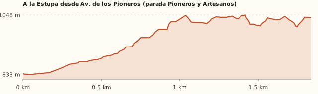
Trail profile
"Pioneros y Artesanos" bus stop → Stupa
- Length
- ≈1.8 km
- Elevations
- 835 → ≈1.040 m
- Elevation gain
- ≈+200 m net
- Uphill
- 30–45 min (on our visit: 25–40)
- Downhill
- 20–30 min
- Difficulty
- Easy to moderate
The model shows extra ups and downs because of terrain noise; what matters is the ≈200 m net gain. Times calculated at an easy pace, without stops.
How to get there
Car, taxi or remis
7.8 km · about 15 min (last streets on gravel)
- Take Av. de los Pioneros to around km 4.
- Drive up through the Ladera Norte neighborhood along Las Ostras and Cacique Saihueque (gravel) to the end.
Bus + climb
Lines 50, 51 and 55 + 1.8 km uphill
- Take line 50 (A, B or C), 51 or 55A along Av. de los Pioneros.
- Get off at "Pioneros y Artesanos".
- Walk up ≈1.8 km through the neighborhood streets to the end of Cacique Saihueque (30 to 45 min).
The climb
≈200 m elevation gain along gravel streets
- It is a steady climb on gravel streets: take it easy.
- At the top, walk around the stupa clockwise and in silence.
What it's like, in numbers
Almost always empty. Very few visitors.
Slopes or uneven ground. Short, but a steady climb.
Nature with houses or a road nearby. A forested slope with a view, with the neighborhood around it.
Exposed. An open slope facing the lake. To be checked
Bus + 1–3 km walk. Bus plus a 1.8 km climb.
None. None. To be checked
Good. Short, for kids who can walk.
What you want to know
Does it cost money?
We found no fee.
- EntranceARS 0We found no fee. To be checked
- Bus (one way)ARS 2,333.30With a SUBE card. Standard fare for sections I to III; residents with a registered SUBE card ARS 1,749.98 (since 30/07/2026).
Can I bring my dog?
On a leash, and don't let it climb onto the monument.
What the rules say
It is outside the National Park (measured).
What happens in practice
People go with dogs (our own experience).
Context
Pets are not allowed in Nahuel Huapi National Park or in Llao Llao Municipal Park (guide dogs only).
- What's the easiest way to get there?
- By car
No bus nearby: the closest stop is 1.8 km away.
- How long does it take?
- 1 h 30 to 2 h 30
On site 1 a 2 h + 15 min by car each way.
- Are there toilets or food?
- No, bring everything
None. None.
- When is the best time?
- Good time right now
All year round. To see the sun set over the lake, March to September.
Reviews
“A Buddhist monument on the slope of Cerro Otto overlooking Lake Nahuel Huapi.”
If you like this place…
Casa de Piedra Stream Trail
Great for: a short forest walk · mate or a picnic by the stream
Refugio Berghof (Cerro Otto)
Great for: a hut 15 minutes from downtown · learning about Bariloche's history
Cerro Campanario
Great for: the panoramic photo of Bariloche · a short but steep climb
Fact sheet
- Type
- Viewpoints · Hiking and walks
- Activities
- Short climb · Viewpoint · Sunset · Silence and meditation
- Area
- Ladera Norte, Cerro Otto
- Location
- End of Cacique Saihueque street (Saihueque 1000), Ladera Norte neighborhood, on Cerro Otto
- Distance from the Civic Center
- 7.8 km · 15 min by car · 1 h 49 on foot
- Time on site
- 1 a 2 h (climb, time at the stupa and walk down)
- Whole outing by car
- 1 h 30 to 2 h 30
- Trail length
- ≈1.8 km uphill from Av. de los Pioneros (3.6 km round trip)
- Route type
- Out and back along neighborhood streets
- Elevation gain
- ≈+200 m
- Elevation
- ≈835 m above sea level (Av. de los Pioneros) · max. ≈1,040 m above sea level (the stupa)
- Difficulty
- Easy to moderate: a steady climb
- Terrain
- Gravel streets of the neighborhood
- Signposting
- No signs: follow Cacique Saihueque to the end
- Water on the way
- None
- Nearby bus lines
- 50, 51, 55 (stop 1.8 km away)
- Gravel road
- Yes, on the last stretch
- Toilets
- No · None
- Food
- No · None
- Lifeguards
- No · Not applicable
- Shade
- No · Little
- Phone signal
- Yes · Good (urban area)
- Best months
- Jan, Feb, Mar, Apr, May, Jun, Jul, Aug, Sep, Oct, Nov, Dec
- Dogs
- Yes, on a leash
- Cost
- Free
- Data checked on
- November 18, 2026
What to bring
- A warm layer for the sunset
- A flashlight if you come down after dark
- Water
Tips
- For a sunset over the lake, go between March and September.
- Head down before it gets completely dark.
Safety
- Gravel streets are slippery on the way down.
- Respect the place: it is a sacred space.
Sources for this page (3)
Most sources are in Spanish.
- Stupa de la Iluminación – Trip.com · s/f
- OpenStreetMap: estupa, calles y paradas · consultado 18/11/2026
- Tarifas de colectivo (Res. 2283/2026) – El Cordillerano · 31/07/2026