All places

Arrayanes Trail (Llao Llao)

The arrayán forest without taking the boat: 3 almost flat km along the shore of Lake Moreno

Great for

Seeing arrayanes without paying for the boat

Without going to the Arrayanes Forest in Villa La Angostura.

An easy walk

2 hours round trip, almost no elevation gain.

Starting with a coffee

The Visitor Center has a café and toilets.

Planning a full day

It ends 100 m from Lake Escondido and the Roman Bridge.

Not for: Going with a dog or by bike: the park doesn't allow it · Climbing the arrayanes · Very windy days: the park closes

The experience

What to do there

An almost flat 3 km trail that starts at the Llao Llao Municipal Park Visitor Center. After 10 minutes you enter a small grove dominated by arrayanes, the tree with the cinnamon-colored trunk. Then the trail follows the shore of Lake Moreno, with views of Cerro López, Cerro Goye and Isla de los Conejos; a short detour leads to the Lake Moreno Viewpoint, with benches for a break.

In almost an hour you come out on the Circuito Chico again, near the ranger's house, where the trails to Lake Escondido and the Roman Bridge start. You come back along the same trail or along the road. In December 2025 the city fenced off the oldest arrayanes because people were climbing them for photos: don't climb or lean on them.
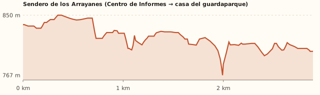
Elevation

Trail profile

Elevation profile: Visitor Center → Circuito Chico (ranger's house)

Visitor Center → Circuito Chico (ranger's house)

Length
3 km (2.9 km measured)
Elevations
837 → 800 m (between 767 and 850 m)
Elevation gain
≈35 m
Out
≈50 min – 1 h
Back
≈50 min – 1 h
Difficulty
Easy

The terrain model shows more ups and downs because of terrain noise. Bariloche Trekking gives 35 m of elevation gain and 2 h round trip. Times calculated at an easy pace, without stops.

Location and directions

How to get there

You arrive at: Llao Llao Municipal Park Visitor Center. On the left side of the Circuito Chico, 1 km past Puerto Pañuelo. The trail starts there (East entrance).

Car, taxi or remis

25.8 km · about 38 min from the Civic Center

Where to park: Visitor Center parking lot
Free (Bariloche Trekking). View on Google Maps
Don't leave valuables in the car.
  1. Take Av. Bustillo to Puerto Pañuelo (km 25).
  2. Continue 1 km along the Circuito Chico: the Visitor Center and its free parking lot are on the left.
  3. Before going in, register and pay the entrance fee (tourists) with the QR code.
Open this route in Google Maps
Ratings from 1 to 5

What it's like, in numbers

How crowded is it?2/5
Very few peopleVery crowded

Few people. You meet fewer people than at Lake Escondido or Tacul. To be checked

How physically demanding is it?2/5
Very easyVery hard

Short, flat walk. Almost flat, 3 km one way.

How much nature is there?5/5
Very littleA lot

Pure nature. Native forest and lakeshore.

Does it work on a windy day?4/5
Very exposedVery sheltered

Sheltered. Almost entirely inside the forest. To be checked

Is it easy to get there without a car?3/5
HardVery easy

Bus + 1–3 km walk. Bus plus a 1.1 km walk.

Are there facilities?3/5
NoneFull

Some. Toilets and café at the start; nothing on the trail.

Is it good with kids?4/5
Not recommendedIdeal

Good. No slopes; long for very small kids if you do the round trip.

In 10 seconds

What you want to know

Does it cost money?

Free for Bariloche residents, retirees and children under 12. Tourists pay the Llao Llao Municipal Park entrance fee (amount to be confirmed).

  • Llao Llao Municipal Park entranceTo be confirmedPaid online, with the QR code at the entrance, or in cash at Rapipago or Pago Fácil. Free for Bariloche residents, retirees and children under 12. In 2023 it cost ARS 250; we couldn't find the current fee. To be checked
  • ParkingARS 0At the Visitor Center. Parking at Puerto Pañuelo is paid.
  • Bus (one way)Higher fare sectionWith a SUBE card. Because of the distance a higher section may be charged (section IV: ARS 3,383.32): confirm when you board.

Can I bring my dog?

Not allowed

Leave your dog at home: the park doesn't allow pets.

What the rules say

Pets are not allowed in Llao Llao Municipal Park, nor are fires, smoking or cycling on the trails (ANBariloche, Nov. 2026; Diario Río Negro).

What happens in practice

"Bikes and pets are banned on all trails of Llao Llao Municipal Park" (Bariloche Trekking). The trail is inside the park (measured).

Context

Pets are not allowed in Nahuel Huapi National Park or in Llao Llao Municipal Park (guide dogs only).

What's the easiest way to get there?
By car

No bus nearby: the closest stop is 1.1 km away.

How long does it take?
3 to 4 h

Walking 1 h 30 a 2 h 30 + 38 min by car each way.

Are there toilets or food?
Yes

At the Visitor Center, at the start. Café at the Visitor Center.

When is the best time?
Good time right now

All year round. The park closes in strong wind.

What people say

Reviews

What media, guides and visitors say
Media, guides and forums

“After a 10-minute easy walk you reach an arrayán forest; then the shore of Lake Moreno, with views of Cerro López and Cerro Goye.”

Bariloche Trekking
Media, guides and forums

“The Lake Moreno viewpoint, on a short detour from the trail, is ideal for a quiet break.”

Komoot, dic. 2025
All reviews and photosOpen Arrayanes Trail (Llao Llao) in Google Maps

If you like this place…

Fact sheet

Type
Hiking and walks · Lakes and lagoons
Activities
Almost flat walk · Arrayán forest · Lake Moreno Viewpoint
Area
Circuito Chico · Llao Llao Municipal Park
Location
Llao Llao Municipal Park Visitor Center, Circuito Chico, 1 km past Puerto Pañuelo
Distance from the Civic Center
25.8 km · 38 min by car · 5 h 50 on foot
Time walking
1 h 30 a 2 h 30 (round trip, with stops)
Whole outing by car
3 to 4 h
Trail length
3 km one way (6 km round trip)
Route type
Out and back, or return along the road
Elevation gain
≈35 m
Elevation
≈835 m s.n.m. · max. ≈850 m s.n.m.
Difficulty
Easy
Terrain
Dirt, almost flat
Signposting
Signposted
Water on the way
Lake Moreno, alongside
Nearby bus lines
20 (stop 1.1 km away)
Gravel road
No, paved all the way
Toilets
Yes · At the Visitor Center, at the start
Food
Yes · Café at the Visitor Center
Lifeguards
No · Not applicable
Shade
Yes · Forest along almost the whole route
Phone signal
No · Areas without signal (Bariloche Trekking)
Best months
Jan, Feb, Mar, Apr, May, Jun, Jul, Aug, Sep, Oct, Nov, Dec
Dogs
Not allowed
Cost
Entrance fee (tourists)
Data checked on
November 18, 2026

What to bring

  • Water
  • A light jacket
  • Mate for the viewpoint

Tips

  • Add Lake Escondido or the Roman Bridge: they start where this trail ends.
  • Start with a coffee at the Visitor Center.

Safety

  • Don't climb or lean on the arrayanes: they are protected.
  • Be careful walking on the road: there are cars and bikes.
Sources for this page (6)

Most sources are in Spanish.

Photos: Pierre Pericard (CC BY-SA 3.0), Laurian Verré (CC BY-SA 3.0), Guillaume Bonastre (CC BY 2.0), Guillermo Murno (CC BY-SA 2.5), iNaturalist (dominio público) (CC0), via Wikimedia Commons.