All places

Villa Tacul and the Roman Bridge

The beaches at the tip of the Llao Llao peninsula, with a stone bridge and a forest viewpoint

Great for

A beach day in the forest

Small bays on Lake Nahuel Huapi, with shade right down to the shore.

A flat walk with a reward

2.5 km with almost no elevation gain, with the Roman Bridge and a viewpoint on the way.

Going with kids or older people

Simple trails, with signs at every junction.

Combining it with Lake Escondido

Both start from the same parking lot.

Autumn and winter sunsets

The bays face northwest: from April to August the sun sets almost over the lake (measured, to be checked). In summer it hides behind the hills about an hour earlier.

Not for: Going with a dog: the park doesn't allow it · Lighting fires or camping: it is forbidden · Very windy days: the park closes

The experience

What to do there

Villa Tacul is the northern tip of the Llao Llao peninsula: small bays and beaches on Lake Nahuel Huapi, tucked into a forest of coihues, cypresses and arrayanes over 30 meters tall. From the shore you can see Isla Centinela, where the remains of Perito Moreno rest. On one point stand the ruins of a 1946 hotel that the Army tore down a decade later and that is the subject of all kinds of legends.

You can drive to the village or take an almost flat trail that starts opposite the ranger's house (the same as for Lake Escondido): it crosses the Roman Bridge, an old stone bridge, continues to a bay viewpoint and goes down to the beaches. From the beach, another 20-minute trail leads to the Tacul Viewpoint, overlooking Cerro Capilla and the Tristeza arm.
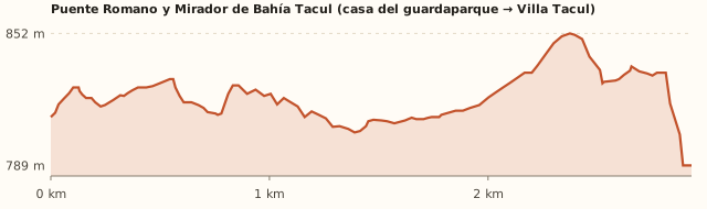
Elevation

Trail profile

Elevation profile: Ranger's house → Roman Bridge → Villa Tacul

Ranger's house → Roman Bridge → Villa Tacul

Length
2.5 km (2.9 km measured)
Elevations
812 → 789 m (beach)
Elevation gain
≈30 m
Out
≈50 min
Back
≈50 min
Difficulty
Easy

Villa Tacul → Tacul Viewpoint

Length
Short
Elevations
—
Elevation gain
—
Out
≈20 min
Back
≈15 min
Difficulty
Easy

The terrain model shows more ups and downs because of terrain noise. Bariloche Trekking gives 30 m of elevation gain and 1 h 30 round trip to the bay viewpoint. Times calculated at an easy pace, without stops.

Location and directions

How to get there

You arrive at: Villa Tacul parking lot. In the village, next to the beach. To walk the trail from the start, park opposite the ranger's house.

Car, taxi or remis

29.4 km · about 45 min from the Civic Center

Where to park: Villa Tacul parking lot
Free (Bariloche Trekking). In December 2025 the access road, which was very narrow, was widened. View on Google Maps
In summer it fills up. Don't leave anything visible in the car.
  1. Take Av. Bustillo to Puerto Pañuelo (km 25) and continue along the Circuito Chico.
  2. Enter Villa Tacul via the park access road and park in the village (free).
  3. To walk the whole trail: park opposite the ranger's house (4 km past Puerto Pañuelo) and walk to the beach.
  4. Before going in, register and pay the entrance fee (tourists) with the QR code.
Open this route in Google Maps
Ratings from 1 to 5

What it's like, in numbers

How crowded is it?3/5
Very few peopleVery crowded

Moderately busy. One of the most visited corners of the park in summer; quiet off season.

How physically demanding is it?2/5
Very easyVery hard

Short, flat walk. A short, almost flat walk.

How much nature is there?5/5
Very littleA lot

Pure nature. Native forest and beaches without buildings.

Does it work on a windy day?3/5
Very exposedVery sheltered

Some shelter. The forest is sheltered; the beaches are open to the lake. To be checked

Is it easy to get there without a car?2/5
HardVery easy

Car yes, bus stop far away. The bus drops you 4.6 km away, at Puerto Pañuelo.

Are there facilities?2/5
NoneFull

Minimal. Toilets at the beach according to OpenStreetMap; we found no food. To be checked

Is it good with kids?4/5
Not recommendedIdeal

Good. Short, flat and signposted.

How warm is the water?1/5
FreezingMild

Cold (big lake). Lake Nahuel Huapi is cold.

In 10 seconds

What you want to know

Does it cost money?

Free for Bariloche residents, retirees and children under 12. Tourists pay the Llao Llao Municipal Park entrance fee (amount to be confirmed).

  • Llao Llao Municipal Park entranceTo be confirmedPaid online, with the QR code at the entrance, or in cash at Rapipago or Pago Fácil. Free for Bariloche residents, retirees and children under 12. In 2023 it cost ARS 250; we couldn't find the current fee. To be checked
  • ParkingARS 0At Villa Tacul and opposite the ranger's house (Bariloche Trekking).
  • Bus (one way)Higher fare sectionWith a SUBE card. Because of the distance a higher section may be charged (section IV: ARS 3,383.32): confirm when you board.

Can I bring my dog?

Not allowed

Leave your dog at home: the park doesn't allow pets.

What the rules say

Pets are not allowed in Llao Llao Municipal Park, nor are fires, smoking or cycling on the trails (ANBariloche, Nov. 2026; Diario Río Negro).

What happens in practice

In Tacul it is forbidden "to enter with animals": "they scare the native wildlife away", the ranger explained. There are huillín otters, kodkod wild cats and Magellanic woodpeckers (Río Negro). The beaches, the bridge and the viewpoint are inside the park (measured).

Context

Pets are not allowed in Nahuel Huapi National Park or in Llao Llao Municipal Park (guide dogs only).

What's the easiest way to get there?
By car

No bus nearby: the closest stop is 4.6 km away.

How long does it take?
3 h 30 to a full day

On site 2 a 6 h + 45 min by car each way.

Are there toilets or food?
Yes

At the beach, according to OpenStreetMap. None found.

When is the best time?
Good time right now

November to April for the beach; the trail, all year round. The park closes in strong wind.

What people say

Reviews

What media, guides and visitors say
Media, guides and forums

“All the trails are easy, ideal for families with kids or older people.”

Diario Río Negro
Media, guides and forums

“One of the most visited corners of Llao Llao Municipal Park in summer.”

ANBariloche, dic. 2025
All reviews and photosOpen Villa Tacul and the Roman Bridge in Google Maps

If you like this place…

Fact sheet

Type
Beaches · Hiking and walks · Viewpoints
Activities
Beaches in the forest · Almost flat walk · Roman Bridge · Tacul Viewpoint
Area
Circuito Chico · Llao Llao Municipal Park
Location
Villa Tacul, northern tip of the Llao Llao peninsula (Circuito Chico, past Puerto Pañuelo)
Distance from the Civic Center
29.4 km · 45 min by car · 6 h 55 on foot
Time on site
2 a 6 h (beach and trail; about a 50-minute walk each way)
Whole outing by car
3 h 30 to a full day
Trail length
2.5 km one way from the ranger's house (5 km round trip)
Route type
Out and back, or drive straight to the beach
Elevation gain
≈30 m
Elevation
≈810 m s.n.m. · max. ≈850 m s.n.m.
Difficulty
Easy
Terrain
Dirt, almost flat
Signposting
Wooden signs at every junction
Water on the way
The lake, at the end
Nearby bus lines
20 (stop 4.6 km away)
Gravel road
No, paved all the way
Toilets
Yes · At the beach, according to OpenStreetMap
Food
No · None found
Lifeguards
No · Not included in the 2025-26 lifeguard program
Shade
Yes · Forest down to the shore
Phone signal
No · Areas without signal (Bariloche Trekking)
Best months
Nov, Dec, Jan, Feb, Mar, Apr
Dogs
Not allowed
Cost
Entrance fee (tourists)
Data checked on
November 18, 2026

What to bring

  • Mate and a snack
  • A beach mat
  • A warm layer: it is cool in the shade
  • A bag for your trash

Tips

  • Combine it with Lake Escondido: it starts from the same parking lot.
  • If you drive, walk the trail the other way round: from the beach to the bridge and back.

Safety

  • Fires and camping are not allowed.
  • Stay on the marked trails.
Sources for this page (6)

Most sources are in Spanish.

Photos: Adrian Bona (CC BY-SA 3.0), Mcampo (CC BY-SA 4.0), Marcelo Campos (CC BY-SA 3.0), Fernando (CC BY-SA 4.0), via Wikimedia Commons.