“Low difficulty, with some slopes that can be demanding for people with reduced mobility or little walking experience.”
Cerro Llao Llao
The easiest viewpoint on the peninsula: forest, arrayanes and a view of three lakes
Great for
3 km one way and 230 m of elevation gain to the viewpoint.
Arrayanes, coihues and amancay flowers in summer.
You can walk down to Villa Tacul.
The Visitor Center has a café and toilets.
Not for: Going with a dog: the park doesn't allow it · Small kids without supervision: there are cliffs at the viewpoint · Very windy days: the park closes
What to do there
The trail starts on the Circuito Chico, 1.3 km from Puerto Pañuelo, and climbs gradually through the forest of Llao Llao Municipal Park to a viewpoint. From the top you see Lake Moreno, Lake Nahuel Huapi, the Tristeza arm and the Andes.
You can walk down to the beach at Villa Tacul. At the Visitor Center, at the start, there are toilets and a café.
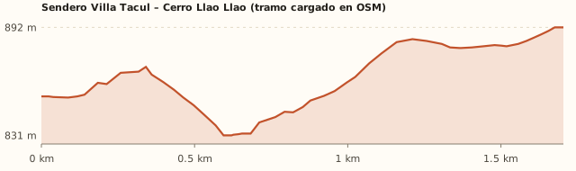
Trail profile
Trailhead → viewpoint
- Length
- 3 km one way
- Elevations
- ≈850 m → to be confirmed
- Elevation gain
- +230 m
- Uphill
- ≈1 h 10
- Downhill
- ≈50 min
- Difficulty
- Moderate
The chart only shows the section mapped in OpenStreetMap (towards Villa Tacul): the last stretch to the viewpoint is missing. Table data: Bariloche Trekking and ANBariloche. Times calculated at an easy pace, without stops.
How to get there
Car, taxi or remis
26.3 km · about 39 min from the Civic Center
- Take Av. Bustillo to Puerto Pañuelo (km 25).
- Continue 1 km along the Circuito Chico to the park Visitor Center and park there (free).
- Walk about 300 m: the trail starts on the right, at the sign "Sendero Cerro Llao Llao y playas".
Bus + walk
Line 20 to Puerto Pañuelo + 1.3 km (≈20 min)
- Take line 20 to Puerto Pañuelo (Llao Llao).
- Walk 1.3 km along the Circuito Chico (≈20 min) to the trailhead. Watch out for cars and bikes.
- Payment: SUBE card only.
The trail
3 km one way · 230 m elevation gain
- Follow the "Villa Tacul – Cerro Llao Llao" signs.
- It climbs gradually through the forest, with some slopes. In ≈1 h 10 you reach the viewpoint.
- You can go back the same way or walk down to Villa Tacul, to the beach.
What it's like, in numbers
Moderately busy. A highly recommended short hike: moderately busy. To be checked
Slopes or uneven ground. Steady slopes, 2 to 3 h.
Pure nature. Native forest from start to finish.
Some shelter. Sheltered in the forest, exposed at the viewpoint. To be checked
Bus + 1–3 km walk. Bus plus a 1.3 km walk.
Some. Toilets and café at the start; nothing on the trail.
With supervision. With supervision: there are cliffs at the viewpoint.
What you want to know
Does it cost money?
Free for Bariloche residents, retirees and children under 12. Tourists pay the Llao Llao Municipal Park entrance fee (amount to be confirmed).
- Llao Llao Municipal Park entranceTo be confirmedPaid online, with the QR code at the entrance, or in cash at Rapipago or Pago Fácil. Free for Bariloche residents, retirees and children under 12. In 2023 it cost ARS 250; we couldn't find the current fee. To be checked
- Trekking registrationFreeBariloche Trekking says the National Park registration is mandatory, but the trail is in the municipal park (measured). Confirm when you arrive. To be checked
- ParkingARS 0At the Visitor Center. Parking at Puerto Pañuelo is paid.
- Bus (one way)Higher fare sectionWith a SUBE card. Because of the distance a higher section may be charged (section IV: ARS 3,383.32): confirm when you board.
Can I bring my dog?
Leave your dog at home: the park doesn't allow pets.
What the rules say
Pets are not allowed in Llao Llao Municipal Park, nor are fires, smoking or cycling on the trails (ANBariloche, Nov. 2026; Diario Río Negro).
What happens in practice
It is a municipal park rule: the place is outside the National Park, but inside Llao Llao Municipal Park (measured on OpenStreetMap).
Context
Pets are not allowed in Nahuel Huapi National Park or in Llao Llao Municipal Park (guide dogs only).
- What's the easiest way to get there?
- By car
No bus nearby: the closest stop is 1.3 km away.
- How long does it take?
- 3 h 30 to 4 h 30
Walking 2 a 3 h + 39 min by car each way.
- Are there toilets or food?
- Yes
At the Visitor Center, at the start. Café at the Visitor Center.
- When is the best time?
- Good time right now
All year round; the amancay flowers bloom in summer. The park closes in strong wind.
Reviews
“There are drop-offs at the viewpoint: keep an eye on kids.”
If you like this place…
Bahía López and the Brazo Tristeza Viewpoint
Great for: kayaking or SUP in calm water · one of the best views of the lake
Villa Tacul and the Roman Bridge
Great for: a beach day in the forest · a flat walk with a reward
Lake Gutiérrez Viewpoint
Great for: a short climb with a big view · adding it to Cascada de los Duendes
Fact sheet
- Type
- Hiking and walks · Viewpoints
- Activities
- Short hike · Viewpoint · Native forest · Walk down to Villa Tacul
- Area
- Circuito Chico · Llao Llao Municipal Park
- Location
- Circuito Chico, 1.3 km from Puerto Pañuelo, near the Llao Llao Municipal Park Visitor Center
- Distance from the Civic Center
- 26.3 km · 39 min by car · 7 h 05 on foot
- Time walking
- 2 a 3 h (round trip, with time at the viewpoint)
- Whole outing by car
- 3 h 30 to 4 h 30
- Trail length
- 3 km one way to the viewpoint (6 km round trip)
- Route type
- Out and back (you can walk down to Villa Tacul)
- Elevation gain
- ≈+230 m
- Elevation
- ≈850 m s.n.m. · max. To be confirmed
- Difficulty
- Easy, with slopes
- Terrain
- Dirt and roots
- Signposting
- Signposted: "Villa Tacul – Cerro Llao Llao"
- Water on the way
- No water along the way
- Nearby bus lines
- 20 (stop 1.3 km away)
- Gravel road
- No, paved all the way
- Toilets
- Yes · At the Visitor Center, at the start
- Food
- Yes · Café at the Visitor Center
- Lifeguards
- No · Not applicable
- Shade
- Yes · Forest along almost the whole route
- Phone signal
- No · Areas without signal (Bariloche Trekking)
- Best months
- Jan, Feb, Mar, Apr, May, Jun, Jul, Aug, Sep, Oct, Nov, Dec
- Dogs
- Not allowed
- Cost
- Entrance fee (tourists)
- Data checked on
- November 18, 2026
What to bring
- Water
- A light jacket: it is windy at the viewpoint
- Sneakers with good grip
Tips
- Walk down to Villa Tacul and finish at the beach.
- Start with a coffee at the Visitor Center.
Safety
- There are cliffs at the viewpoint: always hold kids' hands.
- Camping and fires are not allowed.
Sources for this page (5)
Most sources are in Spanish.
- Llao Llao peak – Bariloche Trekking · consultado 18/11/2026
- Siete trekkings cortos – ANBariloche · 11/11/2026
- Komoot: Cerro Llao Llao por Villa Tacul · s/f
- OpenStreetMap: sendero, Centro de Informes y límite del parque · consultado 18/11/2026
- Tarifas de colectivo (Res. 2283/2026) – El Cordillerano · 31/07/2026
Photos: Pierre Pericard (CC BY-SA 3.0), Los Paseos (CC BY-SA 2.0), Los Paseos (CC BY-SA 2.0), Luna929e9 (CC BY 4.0), Fer3d (CC BY-SA 2.0), via Wikimedia Commons.