All places

Refugio Agostino Rocca (Paso de las Nubes)

Tronador's most modern hut, facing the Frías glacier: 14 km from Pampa Linda and a boat back across Lake Frías

Great for

A comfortable hut in the high mountains

Rooms, showers and a guest kitchen.

The Pampa Linda – Puerto Frías traverse

Returning by boat across Lake Frías.

Seeing the Frías glacier

Straight ahead from the hut.

Not for: Camping: there's no camping area · Bringing a dog: it's a National Park · Going without a car or a booked transfer

The experience

What to do there

The Club Andino's newest and largest hut: 80 places in 10 rooms, showers, power from its own turbine and a kitchen where you can cook your own food, plus the hut's dining room. From the knoll you can see Cerro Constitución, the Frías glacier, Tronador's peaks and Lake Frías.

You climb from Pampa Linda up the Alerce river valley. The classic traverse continues the next day to Puerto Frías and crosses the lake by boat: the last one leaves at 14:30 and must be booked.

Sleeping in the mountains

The hut: booking, food and facilities

Booking

Book on the hut's website before going up.

Capacity

80 places in 10 rooms. No camping.

Food

The hut's dining room and a kitchen to cook your own food.

Showers

Yes, powered by its own turbine.

Return by boat

Going down to Puerto Frías, the Lake Frías boat leaves at 14:30: book it in advance (Turisur).

Road

The gravel road between Los Rápidos and Pampa Linda is one-way by schedule: up from Los Rápidos 10:30 to 14:00, down from Pampa Linda 16:00 to 18:00, and two-way from 19:30 to 9:00 (National Parks, 14/11/2026).

Contact

refugioagostinorocca.com · minibus +54 9 294 421-3932

Rates published by the hut for the 2026/27 season.
Elevation

Trail profile

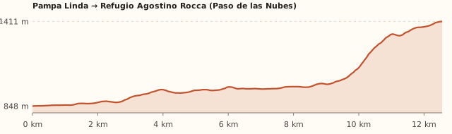
Elevation profile: Pampa Linda → Refugio Agostino Rocca

Pampa Linda → Refugio Agostino Rocca

Length
12.6 km
Elevations
850 → 1.410 m
Elevation gain
+640 m
Uphill
≈4 h 50
Downhill
≈3 h 45
Difficulty
Easy to moderate
  1. It leaves Pampa Linda towards the Alerce river valley.
  2. It follows the valley through the forest and climbs to Paso de las Nubes.
  3. The hut sits on a knoll overlooking the Frías glacier and the Alerce valley.

Measured on OpenStreetMap trails. The Club Andino gives 14.3 km, 530 m and 4 to 6 h; Bariloche Trekking, 14 km, 600 m and 5 to 6 h. Times calculated at an easy pace, without stops.

Location and directions

How to get there

You arrive at: Pampa Linda. At the end of the Tronador road, next to the ranger station.

Car or remis

≈85 km · about 2 h · road with set hours

Where to park: Pampa Linda To be checked
Next to the ranger station. View on Google Maps
Don't leave anything in sight.
  1. Take Ruta 40 south (towards El Bolsón) along lakes Gutiérrez and Mascardi.
  2. At km 35–36, Villa Mascardi, turn right towards Tronador. You pay the National Park entrance fee at the ranger checkpoint.
  3. Continue on the gravel road, cross the Manso river and pass the Los Rápidos campsite.
  4. Mind the schedule: from Los Rápidos you can only go up from 10:30 to 14:00 and down from 16:00 to 18:00 (two-way from 19:30 to 9:00).
  5. It's about 85 km in total (2 h). Park at Pampa Linda, next to the ranger station.
Open this route in Google Maps
Ratings from 1 to 5

What it's like, in numbers

How crowded is it?2/5
Very few peopleVery crowded

Few people. Much less crowded than the huts near Bariloche. To be checked

How physically demanding is it?4/5
Very easyVery hard

Several hours or a lot of climbing. Long (14 km) but with moderate elevation gain.

How much nature is there?5/5
Very littleA lot

Pure nature. Forested valley, glacier and high mountains.

Does it work on a windy day?2/5
Very exposedVery sheltered

Exposed. The pass is windy. To be checked

Is it easy to get there without a car?1/5
HardVery easy

Vehicle only. No bus: car or seasonal minibus.

Are there facilities?4/5
NoneFull

Quite a few. Rooms, showers, guest kitchen and dining room.

Is it good with kids?2/5
Not recommendedIdeal

Older kids only. For older kids who like walking. To be checked

In 10 seconds

What you want to know

Does it cost money?

You pay the National Park entrance fee at Villa Mascardi (ARS 15,000 for Argentines). A bed costs ARS 120,000 per person (hut, 2026/27 season).

  • National Park entrance (Villa Mascardi checkpoint)ARS 15,000Argentines ARS 15,000; Río Negro residents ARS 8,000; foreigners ARS 35,000; students ARS 12,000. Free for retirees, under-6s and Bariloche residents. Second day, 50% off (APN, from 1/6/2026).
  • Overnight stayARS 120,000Per person.
  • BreakfastARS 49,000
  • MealsARS 49,000 a ARS 96,100
  • Sleeping bag rentalARS 34,000
  • Boat across Lake FríasAskTurisur; the last one leaves at 14:30. Book it in advance. To be checked

Can I bring my dog?

Not allowed

Leave your dog at home: it's a National Park and the hut won't take it.

What the rules say

The trail and the hut are inside Nahuel Huapi National Park (measured against the official boundaries in OpenStreetMap), where pets are not allowed, except guide dogs.

What happens in practice

Club Andino huts don't accept pets either. In February 2026 the National Parks again warned about people bringing dogs in, after one bit a park ranger (ANBariloche).

Context

Pets are not allowed in Nahuel Huapi National Park or in Llao Llao Municipal Park (guide dogs only).

What's the easiest way to get there?
By car

No bus nearby: the closest stop is 10 km away.

How long does it take?
2 days (1 night)

Trip 4 to 6 h up; back the same way or down to Puerto Frías and across by boat, plus the trip to the meeting point.

Do I need to book?
Yes

With 80 beds there's usually room, but book and arrange your transfer.

Can I do it as a day trip?
Not advisable

It's 28 km round trip and the Pampa Linda road has set downhill hours.

Are there toilets or food?
Yes

At the hut, with showers. The hut's dining room and a guest kitchen.

When is the best time?
Good time right now

November to April (Club Andino). Out of season, the hut may be closed to the public: check first.

What people say

Reviews

What media, guides and visitors say
Media, guides and forums

“Easy to moderate from November to April: 14.3 km, 530 m of elevation gain and 4 to 6 h.”

Club Andino Bariloche
Media, guides and forums

“It has 80 places, showers, a first-aid room and a guest kitchen.”

Club Andino Bariloche
All reviews and photosOpen Refugio Agostino Rocca (Paso de las Nubes) in Google Maps

If you like this place…

Fact sheet

Type
Mountain huts · Hiking and walks
Activities
Full-day hike · Overnight in a mountain hut · Traverse to Puerto Frías · Glaciers
Area
Pampa Linda · Paso de las Nubes · Nahuel Huapi National Park
Location
On Tronador's eastern slope, at Paso de las Nubes, at about 1,400 m
Distance from the Civic Center
85 km · 2 h by car
Time trip
2 days (1 night) (4 to 6 h up; back the same way or down to Puerto Frías and across by boat)
Whole outing by car
2 days (1 night)
Trail length
≈12.5 to 14 km one way
Route type
Out and back, or a traverse to Puerto Frías returning by boat
Elevation gain
≈+550 a +650 m
Elevation
≈850 m at Pampa Linda · max. ≈1,400–1,430 m at the hut
Difficulty
Easy to moderate (Club Andino): long but with little elevation gain
Terrain
Forest trail up the Alerce river valley and a final climb to the pass
Signposting
Marked trail
Water on the way
Streams along the way
Meeting point
Arranged when you book
Toilets
Yes · At the hut, with showers
Food
Yes · The hut's dining room and a guest kitchen
Lifeguards
No · Not applicable
Shade
Yes · Forest in the valley
Phone signal
No · No signal
Best months
Nov, Dec, Jan, Feb, Mar, Apr
Dogs
Not allowed
Cost
Park entrance
Data checked on
November 19, 2026

What to bring

  • Warm layers and windbreaker
  • Rain jacket
  • Food if you'll use the guest kitchen
  • Cash
  • Sleeping bag (or rent one)
  • Boat booking if you go down to Puerto Frías

Tips

  • If you do the traverse, leave the hut early: the Lake Frías boat leaves at 14:30.
  • From the Rocca you can also descend to Laguna Ilón via the La Marca pass (with experience).

Safety

  • Log your hike in the National Park trekking registration.
  • The descent to Puerto Frías is long and muddy: time it carefully for the boat.
Sources for this page (6)

Most sources are in Spanish.

Photos: Stevage (CC BY-SA 3.0), Isha (Public domain), via Wikimedia Commons.