All places

Refugio El Retamal (El Bolsón)

A small, quiet hut at the foot of Dedo Gordo, an hour beyond Cajón del Azul

Great for

Sleeping away from the Cajón crowds

One more hour and far fewer people.

Continuing on the Circuito Troncal

Towards La Horqueta and Los Laguitos.

Not for: Bringing a dog · Arriving late in January: it fills up · Gluten-free diets: there are no options

The experience

What to do there

A simple, quiet hut with a shared mattress room, kitchen, shower and home-made meals. It sits at 750 m, at the foot of Dedo Gordo, and is the natural stop on the way to La Horqueta and Los Laguitos.

Walks from the hut go to Paso de los Vientos, Paredón de las Águilas and Miradores Grandes. It's small: in high season it's best to arrive before 2 pm.

Sleeping in the mountains

The hut: booking, food and facilities

Mandatory registration

Before you set off, register at anprale.com (free, with daily quotas) and submit the descent notice when you get back.

Booking

No bookings. It's small: if it fills up, mattresses are shared or you're sent by radio to another hut.

Hours

Check-in until 8 pm in summer; in high season, arrive before 2 pm.

Where to sleep

Shared room with mattresses (bring a sleeping bag) and camping.

Food

Home-made meals you sign up for on arrival; shop open 8:00 to 23:00. No gluten-free options.

Payment

Cash only: there's no signal or internet.

Rules

No pets, no speakers.

Contact

@refugioelretamal

The hut's 2026/27 season information.
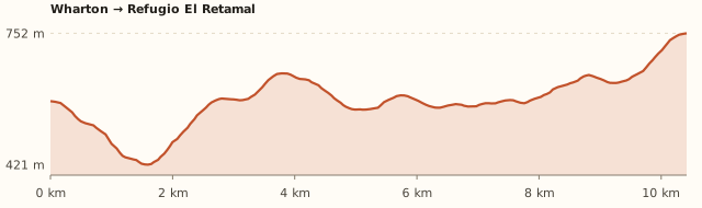
Elevation

Trail profile

Elevation profile: Wharton → Refugio El Retamal

Wharton → Refugio El Retamal

Length
10.4 km
Elevations
580 → 750 m
Elevation gain
+490 m / −320 m
Out
≈4 h 15
Back
≈3 h 45
Difficulty
Moderate
  1. Wharton – La Playita – Cajón del Azul along the Circuito Troncal.
  2. From the Cajón, another hour of climbing, signposted with yellow letters.

Measured on OpenStreetMap trails. The hut says 13 km and 4 h 30 to 6 h one way. Times calculated at an easy pace, without stops.

Location and directions

How to get there

You arrive at: Chacra Wharton (start of the Circuito Troncal). 14 km from El Bolsón. It's the start of the trail to the Azul river huts; there's parking and a checkpoint in season.

Car or remis

≈110 km · 1 h 40 from Bariloche to Wharton

Where to park: Wharton car park To be checked
At the trailhead. View on Google Maps
The car stays for one or several days: don't leave anything in sight.
  1. Take Ruta 40 south to El Bolsón (about 120 km).
  2. Before reaching downtown, follow the signs to Wharton / Cajón del Azul, heading northwest.
  3. It's 14 km from El Bolsón to Chacra Wharton, where the trail begins.
  4. In El Bolsón you can also take a remis to Wharton.
Open this route in Google Maps
Ratings from 1 to 5

What it's like, in numbers

How crowded is it?2/5
Very few peopleVery crowded

Few people. Quieter than Cajón del Azul.

How physically demanding is it?4/5
Very easyVery hard

Several hours or a lot of climbing. 13 km one way including the final climb.

How much nature is there?5/5
Very littleA lot

Pure nature. Native forest at the foot of Dedo Gordo.

Does it work on a windy day?4/5
Very exposedVery sheltered

Sheltered. The Azul river valley is sheltered by the forest. To be checked

Is it easy to get there without a car?1/5
HardVery easy

Vehicle only. Far from Bariloche.

Are there facilities?3/5
NoneFull

Some. Kitchen, shower, meals and a small shop.

Is it good with kids?2/5
Not recommendedIdeal

Older kids only. For older kids who like walking. To be checked

In 10 seconds

What you want to know

Does it cost money?

Free!

Hiking up is free. A bed costs ARS 50,000 and camping ARS 25,000 per person; meals ARS 20,000 to ARS 28,000 (2026/27 season).

  • ANPRALE registrationFreeMandatory and personal, before you go up, at anprale.com. There are daily quotas. When you come back, submit the "descent notice" with your registration number.
  • Bed (with kitchen and dishes)ARS 50,000
  • CampingARS 25,000No use of the hut kitchen; there's a free stove under cover.
  • Breakfast / home-made dishesARS 20,000 / ARS 23,000 a ARS 28,000Stew, pizza, sandwiches.
  • Shower / battery chargingARS 10,000 / ARS 5,000Limited showers.

Can I bring my dog?

Not allowed

Leave your dog at home: the huts won't take it.

What the rules say

It is inside the Río Azul – Lago Escondido Protected Natural Area (ANPRALE). The huts on the circuit don't accept pets (Hielo Azul, El Retamal, Los Laguitos and La Horqueta say so explicitly).

What happens in practice

The huts ask you to come without a dog: there is native wildlife (huemul, pudú) and they have nowhere to keep them.

Context

Pets are not allowed in Nahuel Huapi National Park or in Llao Llao Municipal Park (guide dogs only).

What's the easiest way to get there?
By car

No bus nearby: the closest stop is 10 km away.

How long does it take?
2 days (1 night)

Trip 4 h 30 to 6 h one way from Wharton, plus the trip to the meeting point.

Do I need to register?
Yes, at anprale.com

It's mandatory, free and with daily quotas. When you come back, submit the descent notice.

Do I need to book?
No bookings

Arrive before 2 pm in high season.

Can I do it as a day trip?
Not advisable

It's 13 km each way: most people stay the night.

Are there toilets or food?
Yes

At the hut, with a shower. Home-made meals and a shop open 8:00 to 23:00.

When is the best time?
Good time right now

Opens in October and closes after Easter (hut).

What people say

Reviews

What media, guides and visitors say
Media, guides and forums

“It's a small hut: in high season it's best to arrive before 2 pm.”

Refugio El Retamal
All reviews and photosOpen Refugio El Retamal (El Bolsón) in Google Maps

If you like this place…

Fact sheet

Type
Mountain huts · Hiking and walks
Activities
2-day trek · Overnight in a mountain hut · Camping · Viewpoints
Area
El Bolsón · ANPRALE (110 km from Bariloche)
Location
At the foot of Cerro Dedo Gordo, at about 750 m, on the Circuito Troncal
Distance from the Civic Center
110.6 km · 1 h 36 by car
Time trip
2 days (1 night) (4 h 30 to 6 h one way from Wharton)
Whole outing by car
2 days (1 night)
Trail length
≈10.5 to 13 km one way
Route type
Out and back on the Circuito Troncal
Elevation gain
≈+500 m
Elevation
≈580 m at Wharton · max. ≈750 m
Difficulty
Moderate
Terrain
Forest trail, with the final climb signposted
Signposting
Yellow-lettered signs on the climb
Water on the way
Streams along the way
Meeting point
Arranged when you book
Toilets
Yes · At the hut, with a shower
Food
Yes · Home-made meals and a shop open 8:00 to 23:00
Lifeguards
No · Not applicable
Shade
Yes · Forest almost all the way
Phone signal
No · No signal in the valley
Best months
Nov, Dec, Jan, Feb, Mar, Apr
Dogs
Not allowed
Cost
Free to hike up
Data checked on
November 19, 2026

What to bring

  • Sleeping bag (no bedding provided)
  • Cash for everything
  • Hiking boots
  • Rain jacket and warm layers
  • Headlamp
  • A tent as plan B if the hut doesn't take bookings

Tips

  • If you camp, bring a tent, stove and dishes.
  • Leave Wharton early to arrive before 2 pm.

Safety

  • Register at anprale.com before setting off and submit the descent notice when you get back.
  • Don't make fires outside the designated fire pits: there were serious fires in the area in 2025.
  • In heavy rain the area may close: check with El Bolsón's mountain information office (+54 294 445-5336).
Sources for this page (5)

Most sources are in Spanish.

Photos: Salvador Drusin (Flickr) (CC BY 2.0), via Wikimedia Commons.