“No bookings: they recommend arriving around midday to find a place.”
Refugio Cajón del Azul (El Bolsón)
El Bolsón's classic: suspension bridges and a turquoise canyon about 3 hours from Wharton
Great for
Pools in the canyon, in summer.
A well-marked trail without big climbs.
It continues to El Retamal, Casa de Campo and Los Laguitos.
Not for: Bringing a dog · Looking for solitude in January: it's the busiest · Going without cash
What to do there
The Azul river is squeezed between rock walls and forms turquoise pools: it's El Bolsón's postcard image. The hut, with a vegetable garden and cabins, is next to the bridge over the canyon.
The trail starts at Chacra Wharton, 14 km from El Bolsón, and is the beginning of the Circuito Troncal: forest, mountain farms and suspension bridges, passing La Playita. You can do it in a day or sleep up there and continue to El Retamal or Hielo Azul.
The hut: booking, food and facilities
- Mandatory registration
Before you set off, register at anprale.com (free, with daily quotas) and submit the descent notice when you get back.
- Booking
No bookings: they recommend arriving around midday and bringing a tent as plan B.
- Where to sleep
Hut with kitchen, utensils and dishes, plus camping.
- Payment
Cash only: there's no signal or internet.
- Signal
There's no mobile signal at the ANPRALE huts.
- Contact
@refugiocajonazul
November 2026 prices sent by the hut; subject to change.
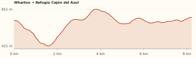
Trail profile
Wharton → Refugio Cajón del Azul
- Length
- 8.3 km
- Elevations
- 580 → 600 m (max. 650 m)
- Elevation gain
- +320 m / −300 m
- Out
- ≈3 h 15
- Back
- ≈3 h
- Difficulty
- Moderate
- It leaves Wharton and crosses the Azul river on a footbridge.
- Forest, mountain farms and suspension bridges to La Playita (6.5 km) and La Tronconada (1.5 km further).
- Another half hour and you reach the canyon: the hut is next to the bridge.
Measured on OpenStreetMap trails. Argentina Trekking gives 12 km and 7 to 8 h round trip; Diario Río Negro, about 4 h one way. Times calculated at an easy pace, without stops.
How to get there
Car or remis
≈110 km · 1 h 40 from Bariloche to Wharton
- Take Ruta 40 south to El Bolsón (about 120 km).
- Before reaching downtown, follow the signs to Wharton / Cajón del Azul, heading northwest.
- It's 14 km from El Bolsón to Chacra Wharton, where the trail begins.
- In El Bolsón you can also take a remis to Wharton.
Coach + local bus
Coach to El Bolsón (≈2 h) + local bus or remis to Wharton
- Long-distance coaches to El Bolsón leave from the Bariloche bus terminal (about 2 h).
- In El Bolsón, on plaza Pagano, there's a La Golondrina stop with a "a Wharton" sign (undated guide: check the times at the tourist office).
- The other option is a remis to Wharton (14 km).
The trail
8.3 km · ≈3 h · forest and suspension bridges
- From Wharton, cross the Azul river and follow the Circuito Troncal.
- After about 6.5 km you pass La Playita (hut and campsite) and 1.5 km later La Tronconada.
- Another half hour and you reach Cajón del Azul: the hut is next to the bridge.
What it's like, in numbers
Packed in high season. It's El Bolsón's most popular hike: it's busy in January.
Slopes or uneven ground. 8 to 10 km each way with gentle ups and downs.
Pure nature. Native forest, river and canyon.
Sheltered. The Azul river valley is sheltered by the forest. To be checked
Vehicle only. Far from Bariloche: car, or bus plus remis.
Some. Hut with kitchen, camping and food.
With supervision. Good for kids who like walking. To be checked
What you want to know
Does it cost money?
Hiking up is free (ANPRALE registration is free). A bed at the hut costs ARS 50,000 and camping ARS 25,000 per person (Nov. 2026).
- ANPRALE registrationFreeMandatory and personal, before you go up, at anprale.com. There are daily quotas. When you come back, submit the "descent notice" with your registration number.
- Bed at the hutARS 50,000With kitchen, utensils and dishes (Nov. 2026).
- CampingARS 25,000Under-12s free.
- Remis El Bolsón – WhartonAsk14 km. To be checked
Can I bring my dog?
Leave your dog at home: the huts won't take it.
What the rules say
It is inside the Río Azul – Lago Escondido Protected Natural Area (ANPRALE). The huts on the circuit don't accept pets (Hielo Azul, El Retamal, Los Laguitos and La Horqueta say so explicitly).
What happens in practice
The huts ask you to come without a dog: there is native wildlife (huemul, pudú) and they have nowhere to keep them.
Context
Pets are not allowed in Nahuel Huapi National Park or in Llao Llao Municipal Park (guide dogs only).
- What's the easiest way to get there?
- By car
No bus nearby: the closest stop is 10 km away.
- How long does it take?
- 10 h 30 to a full day
Round-trip hike 7 to 8 h, or 2 days + 1 h 36 by car each way.
- Do I need to register?
- Yes, at anprale.com
It's mandatory, free and with daily quotas. When you come back, submit the descent notice.
- Do I need to book?
- No bookings
Arrive around midday and bring a tent in case it's full.
- Can I do it as a day trip?
- Yes, in 7 to 8 h
About 3 h each way plus time at the canyon.
- Are there toilets or food?
- Yes
At the hut. Hut with home-made food and a small shop.
- When is the best time?
- Good time right now
November to April (Argentina Trekking). In January and February the canyon water is best for swimming.
Reviews
“You're asked to register on the ANPRALE website: it's a safety measure.”
If you like this place…
Refugio Encanto Blanco (El Bolsón)
Great for: a quiet hut · a gentle climb
FreeRefugio La Playita (El Bolsón)
Great for: your first night in a mountain hut · going with kids
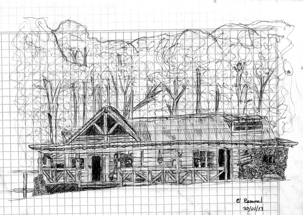
FreeRefugio El Retamal (El Bolsón)
Great for: sleeping away from the Cajón crowds · continuing on the Circuito Troncal
Fact sheet
- Type
- Mountain huts · Hiking and walks · Rivers and streams
- Activities
- Hiking · Overnight in a mountain hut · Camping · Natural pools for swimming · Suspension bridges
- Area
- El Bolsón · ANPRALE (110 km from Bariloche)
- Location
- Next to the Azul river canyon, at about 600 m, on the Circuito Troncal
- Distance from the Civic Center
- 110.6 km · 1 h 36 by car
- Time round-trip hike
- 7 to 8 h, or 2 days (about 3 h each way from Wharton; many sleep at the hut)
- Whole outing by car
- 10 h 30 to a full day
- Trail length
- ≈8.3 km one way (guides say 10 to 12)
- Route type
- Out and back on the Circuito Troncal
- Elevation gain
- ≈+320 m, with descents
- Elevation
- ≈580 m at Wharton · max. ≈650 m
- Difficulty
- Moderate: long but without big climbs
- Terrain
- Forest trail with ups and downs and suspension bridges
- Signposting
- Well-marked, busy trail
- Water on the way
- Streams and the river along the way
- Meeting point
- Arranged when you book
- Toilets
- Yes · At the hut
- Food
- Yes · Hut with home-made food and a small shop
- Lifeguards
- No · Not applicable
- Shade
- Yes · Forest almost all the way
- Phone signal
- No · No signal in the valley
- Best months
- Nov, Dec, Jan, Feb, Mar, Apr
- Dogs
- Not allowed
- Cost
- Free to hike up
- Data checked on
- November 19, 2026
What to bring
- Sleeping bag (no bedding provided)
- Cash for everything
- Hiking boots
- Rain jacket and warm layers
- Headlamp
- A tent as plan B if the hut doesn't take bookings
- Swimsuit and towel
Tips
- Leave Wharton early in January.
- For a day trip, allow 3 h each way.
- La Tronconada has been closed for overnight stays since the 2025 fire: if you want to split the walk, sleep at La Playita.
Safety
- Register at anprale.com before setting off and submit the descent notice when you get back.
- Don't make fires outside the designated fire pits: there were serious fires in the area in 2025.
- In heavy rain the area may close: check with El Bolsón's mountain information office (+54 294 445-5336).
- Take care when swimming: the water is very cold and there's a current in the canyon.
Sources for this page (6)
Most sources are in Spanish.
- Cajón del Azul – Argentina Trekking (precios y datos del refugio, nov. 2026) · consultado 19/11/2026
- Registro obligatorio de visitantes – ANPRALE (Río Negro) · consultado 19/11/2026
- Reabrió el ANPRALE en El Bolsón: cómo registrarse – Noticias Ambientales · 21/09/2026
- Lo que hay que saber para ir al Cajón del Azul – Diario Río Negro · s/f
- Refugios de El Bolsón: estado y precios 2026/27 – Guía Patagonia Andina · act. 18/09/2026
- Medición propia: Wharton → Cajón del Azul (BRouter sobre senderos de OpenStreetMap + modelo de terreno SRTM) · 19/11/2026
Photos: Thalassa16 (CC BY-SA 4.0), TitiNicola (CC BY-SA 4.0), Denisnpg (CC BY-SA 4.0), Ivana nadal (CC BY-SA 4.0), TitiNicola (CC BY-SA 4.0), via Wikimedia Commons.