All places

Refugio Otto Meiling (Mount Tronador)

Sleep between two Tronador glaciers at 1,900 m: 5 to 7 hours up from Pampa Linda

Great for

Sleeping next to a glacier

Between the Castaño Overo and the Alerce.

A high-mountain hike with no climbing

1,000 m of elevation gain on a trail.

Sunsets over the Andes

The view takes in the range towards Chile.

Not for: A day trip: the road schedule doesn't allow it · Bringing a dog: it's a National Park · Days of strong wind or storms on the ridge · Going without a car or a booked transfer

The experience

What to do there

A hut on the La División ridge, surrounded by ice: the Castaño Overo glacier on one side and the Alerce on the other, with Tronador's peaks above. It is one of the most impressive places in Patagonia to sleep without climbing.

The climb starts at Pampa Linda with 3 flat km, continues through the forest to the treeline and ends along a rocky ridge marked with paint. Guided glacier excursions leave from the hut.

Sleeping in the mountains

The hut: booking, food and facilities

Booking

Required to sleep. Meals aren't booked: you order them up top.

Food

At any time; dinner is served at 9 pm.

Open

October to May.

Excursions

Guided from the hut, of varying difficulty.

Road

The gravel road between Los Rápidos and Pampa Linda is one-way by schedule: up from Los Rápidos 10:30 to 14:00, down from Pampa Linda 16:00 to 18:00, and two-way from 19:30 to 9:00 (National Parks, 14/11/2026).

Contact

refugiomeiling.com · +54 9 294 421-3932 (Travel Light)

The hut doesn't publish rates. December 2025 reference: bed ARS 90,000.
Elevation

Trail profile

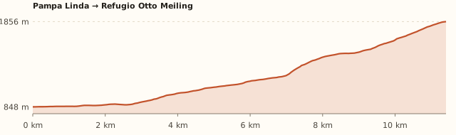
Elevation profile: Pampa Linda → Refugio Otto Meiling

Pampa Linda → Refugio Otto Meiling

Length
11.4 km
Elevations
850 → 1.855 m
Elevation gain
+1.020 m
Uphill
≈5 h 30
Downhill
≈3 h 50
Difficulty
Moderate
  1. From the Pampa Linda ranger station, 3 flat km to the footbridge over the Castaño Overo river.
  2. 6 km climbing along the hillside, with about 500 m of elevation gain, to La Almohadilla.
  3. 2 gentler km to Descanso de los Caballos, where the forest ends.
  4. The last 3 km and 350 m follow the rocky ridge along the paint marks.

Measured on OpenStreetMap trails. The Club Andino gives 14 km, 1,050 m and 5 to 7 h; Bariloche Trekking, 13 km and 5 to 7 h. Times calculated at an easy pace, without stops.

Location and directions

How to get there

You arrive at: Pampa Linda (ranger station). At the end of the Tronador road. The trail starts next to the ranger station.

Car or remis

≈85 km · about 2 h · road with set hours

Where to park: Pampa Linda To be checked
Parking next to the ranger station and the inn. View on Google Maps
You'll leave the car overnight: don't leave anything in sight.
  1. Take Ruta 40 south (towards El Bolsón) along lakes Gutiérrez and Mascardi.
  2. At km 35–36, Villa Mascardi, turn right towards Tronador. You pay the National Park entrance fee at the ranger checkpoint.
  3. Continue on the gravel road, cross the Manso river and pass the Los Rápidos campsite.
  4. Mind the schedule: from Los Rápidos you can only go up from 10:30 to 14:00 and down from 16:00 to 18:00 (two-way from 19:30 to 9:00).
  5. It's about 85 km in total (2 h). Park at Pampa Linda, next to the ranger station.
Open this route in Google Maps
Ratings from 1 to 5

What it's like, in numbers

How crowded is it?3/5
Very few peopleVery crowded

Moderately busy. Far from Bariloche: people in summer, but never crowds. To be checked

How physically demanding is it?5/5
Very easyVery hard

Full day with steep climbing. Over 1,000 m of elevation gain and an exposed final ridge.

How much nature is there?5/5
Very littleA lot

Pure nature. High mountains with glaciers.

Does it work on a windy day?1/5
Very exposedVery sheltered

Very exposed. The ridge and the hut are very exposed. To be checked

Is it easy to get there without a car?1/5
HardVery easy

Vehicle only. No bus: your own car or the seasonal minibus.

Are there facilities?3/5
NoneFull

Some. Hut with food at any time and beds.

Is it good with kids?1/5
Not recommendedIdeal

Not recommended. Not recommended for kids. To be checked

In 10 seconds

What you want to know

Does it cost money?

You pay the National Park entrance fee at the Villa Mascardi checkpoint (ARS 15,000 for Argentines). The hut doesn't publish prices: in December 2025 a bed cost ARS 90,000.

  • National Park entrance (Villa Mascardi checkpoint)ARS 15,000Argentines ARS 15,000; Río Negro residents ARS 8,000; foreigners ARS 35,000; students ARS 12,000. Free for retirees, under-6s and Bariloche residents. Second day, 50% off (APN, from 1/6/2026).
  • Overnight stay≈ARS 90,000December 2025 price (Noticias NQN). The hut doesn't publish rates: ask when you book. To be checked
  • Full board≈ARS 297,000December 2025. To be checked
  • Sleeping bag rental≈ARS 22,500December 2025. To be checked
  • Minibus transferAskTravel Light, in season, booking required. To be checked

Can I bring my dog?

Not allowed

Leave your dog at home: it's a National Park and the hut won't take it.

What the rules say

The trail and the hut are inside Nahuel Huapi National Park (measured against the official boundaries in OpenStreetMap), where pets are not allowed, except guide dogs.

What happens in practice

Club Andino huts don't accept pets either. In February 2026 the National Parks again warned about people bringing dogs in, after one bit a park ranger (ANBariloche).

Context

Pets are not allowed in Nahuel Huapi National Park or in Llao Llao Municipal Park (guide dogs only).

What's the easiest way to get there?
By car

No bus nearby: the closest stop is 10 km away.

How long does it take?
2 days (1 night)

Trip 5 to 7 h up and about 4 h down; because of the road schedule it can't be done as a day trip, plus the trip to the meeting point.

Do I need to book?
Yes, to sleep

Meals are ordered up top without booking.

Can I do it as a day trip?
Not advisable

The climb takes 5 to 7 h and the Pampa Linda road only runs downhill from 16:00 to 18:00 (or at night, from 19:30).

Are there toilets or food?
Yes

At the hut. At the hut, at any time (dinner is at 9 pm).

When is the best time?
Better at another time of year

December to March (the Club Andino says December to April). The hut is open October to May; the road to Pampa Linda has set hours.

What people say

Reviews

What media, guides and visitors say
Media, guides and forums

“Moderate from December to April: 14 km, 1,050 m of elevation gain and 5 to 7 h of walking.”

Club Andino Bariloche
Media, guides and forums

“The last 3 km follow a bare ridge, with paint marks on the rocks.”

Club Andino Bariloche
All reviews and photosOpen Refugio Otto Meiling (Mount Tronador) in Google Maps

If you like this place…

Fact sheet

Type
Mountain huts · Hiking and walks
Activities
Full-day hike · Overnight in a mountain hut · Glaciers · Guided excursions
Area
Pampa Linda · Mount Tronador · Nahuel Huapi National Park
Location
On the La División ridge, between the Castaño Overo and Alerce glaciers, at 1,885 m
Distance from the Civic Center
85 km · 2 h by car
Time trip
2 days (1 night) (5 to 7 h up and about 4 h down; because of the road schedule it can't be done as a day trip)
Whole outing by car
2 days (1 night)
Trail length
≈11.5 to 14 km one way
Route type
Out and back
Elevation gain
≈+1.050 m
Elevation
≈850 m at Pampa Linda · max. ≈1,885 m at the hut
Difficulty
Moderate: long, with 1,000 m of elevation gain
Terrain
Narrow track, forest trail and finally a bare rocky ridge
Signposting
Paint marks on the rocks on the last stretch
Water on the way
Streams lower down; little water up top
Meeting point
Arranged when you book
Toilets
Yes · At the hut
Food
Yes · At the hut, at any time (dinner is at 9 pm)
Lifeguards
No · Not applicable
Shade
Yes · Forest in the middle section; nothing up top
Phone signal
No · No signal
Best months
Dec, Jan, Feb, Mar
Dogs
Not allowed
Cost
Park entrance
Data checked on
November 19, 2026

What to bring

  • Mountain clothing: it's cold up top even in summer
  • Rain jacket and windbreaker
  • Sunglasses and sunscreen
  • Trekking poles
  • Cash
  • Sleeping bag (or rent one)

Tips

  • Plan around the road schedule: drive up from Los Rápidos before 14:00.
  • Book the hut and the transfer together.
  • Some people spend the night at Pampa Linda and hike up the next day.

Safety

  • Log your hike in the National Park trekking registration.
  • Don't walk on the glacier without a guide and gear.
  • On the ridge, in strong wind or fog, turn back: it's easy to lose the markers.
Sources for this page (8)

Most sources are in Spanish.

Photos: Stevage (CC BY-SA 3.0), Zuarin (CC BY 3.0), McKay Savage (CC BY 2.0), McKay Savage (CC BY 2.0), Stevage (CC BY-SA 4.0), via Wikimedia Commons.