All places

Santa Ana and Dora Waterfalls (Samoré Pass)

Two huge waterfalls in Valdivian rainforest, between the border posts on the road to Chile: at Santa Ana, 40 to 50 m high, you can walk behind the water

Great for

Seeing a truly big waterfall

Santa Ana drops 40 to 50 m.

Standing behind the water

A little path climbs to the cave behind the fall.

A hike with a touch of adventure

A river crossing with ropes, ups and downs through the forest.

Combining with Villa La Angostura

The trailhead is 38 km from El Cruce.

Not for: Going without documents: you pass through immigration and customs · Arriving late: there is a latest entry time · Bringing a dog: it is a National Park · Small children or people who do not want to get their feet wet · Days of heavy rain: the river crossing rises

The experience

What to do there

Past the Argentine customs post at the Cardenal Samoré pass, heading to Chile, Route 231 runs through a wet forest of coihues, canelos and cane, similar to the Valdivian rainforest. There, out of sight from the road, two waterfalls drop: Dora, wide and fan-shaped, and Santa Ana, a fall of about 40 to 50 m that has carved a rock cave behind the curtain of water, where you can stand and watch the river fall.

Because the trail lies between the two border posts, you go through immigration as if travelling to Chile, stating that your destination is the waterfalls, and you notify the Gendarmería (border police). The pass opens from 9 to 19, so you need to go in early. It is a full day from Bariloche (about 120 km each way), ideal to combine with Villa La Angostura.

Before you go

Samoré border formalities and hours

Customs and immigration

The trail lies between the Argentine and Chilean customs posts: you go through the formalities as if travelling to Chile and declare that you are going to the waterfalls. They ask for an ID card (or passport) and the vehicle documents.

Gendarmería (border police)

Once at Samoré, tell the Gendarmería office that you are going to the trails.

Trekking registration

Mandatory and free, online on the Nahuel Huapi National Park website, up to 48 h in advance.

Border hours

On the Argentine side, from 9 to 19. You must cross back before closing time.

Latest entry time

When the trails reopened in 2022 the Park set 10 a.m. as the latest time for Santa Ana and 12 noon for Dora. Check on site.

Prohibited

Overnight stays, fires and pets.

From the border complex to the trailhead it is about 13 km. The parking area is on the right of the road, about 100 m before the Pantojo river.
Elevation

Trail profile

Elevation profile: Route 231 → Dora Waterfall

Route 231 → Dora Waterfall

Length
1.6 km
Elevations
1.155 → 1.105 m
Elevation gain
−70 m (short, steep descent at the end)
Out
≈35 to 40 min
Back
≈35 to 40 min
Difficulty
Easy
  1. From the parking area the trail enters the forest. A few metres in there is a signed fork: Dora is straight ahead and Santa Ana branches off to the right.
  2. The last stretch drops short and steep, holding on to the trees, down to the Pireco river.
  3. Walk left along the bank to get closer to the fan of water.

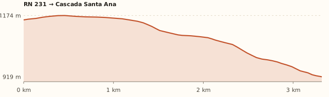
Route 231 → Santa Ana Waterfall

Length
3.4 km
Elevations
1.155 → 920 m
Elevation gain
−250 m on the way in, +250 m on the way back
Out
≈1 h 15 a 1 h 45
Back
≈1 h 30 a 2 h
Difficulty
Moderate
  1. Go back to the fork and head for Santa Ana: about 40 minutes through the forest to the Pireco river.
  2. A sign marks the crossing. There are ropes to hold on to; depending on the flow, the water can reach your knees.
  3. On the other side the trail climbs and drops over loose dirt and ends by descending through the vegetation to the foot of the fall (≈25 min).
  4. A steep little path on the right climbs to the cave behind the curtain of water.

Measured on OpenStreetMap trails. The Park sign gives 4 km, 275 m of elevation and 3 to 5 h round trip; ANBariloche gives 40 min to the fork, 40 more to the crossing and 25 to Santa Ana. Times calculated at an easy pace, without stops.

Location and directions

How to get there

You arrive at: Trailhead parking (Route 231). On the right of the road heading to Chile, about 13 km after the border complex and 100 m before the Pantojo river bridge. There is a National Parks sign.

Car

≈121 km · about 2 h, plus the formalities

Where to park: Roadside pull-out next to the sign
It fills up in summer: arrive early. View on Google Maps
Do not leave anything in sight.
  1. Leave Bariloche towards Dina Huapi and follow Route 40 to Villa La Angostura (signposted), along the north shore of Nahuel Huapi.
  2. It is about 83 km to El Cruce, the centre of Villa La Angostura (≈1 h 20, all paved).
  3. At El Cruce continue on Route 231 towards Chile (Cardenal Samoré pass), along Lake Correntoso.
  4. After about 25 km you reach the border complex (El Rincón): clear the exit formalities saying you are going to the waterfalls and notify the Gendarmería.
  5. Drive about 13 km more. The parking area is on the right, 100 m before the Pantojo river bridge.
Open this route in Google Maps
Ratings from 1 to 5

What it's like, in numbers

How crowded is it?3/5
Very few peopleVery crowded

Moderately busy. In summer more than 100 people a day registered and the parking area fills up.

How physically demanding is it?4/5
Very easyVery hard

Several hours or a lot of climbing. 3 to 5 h, with a river crossing and 250 m of climbing on the way back.

How much nature is there?5/5
Very littleA lot

Pure nature. Wet mountain forest, rivers and two big falls.

Does it work on a windy day?4/5
Very exposedVery sheltered

Sheltered. Valley floor with dense forest. To be checked

Is it easy to get there without a car?1/5
HardVery easy

Vehicle only. By car only: no bus stops at the trailhead.

Are there facilities?1/5
NoneFull

None. Nothing on the trail; toilets at the border complex. To be checked

Is it good with kids?2/5
Not recommendedIdeal

Older kids only. For older kids; Dora alone is shorter and easier. To be checked

In 10 seconds

What you want to know

Does it cost money?

Free!

There is no fee for the trail (Diario Río Negro). The National Park trekking registration is free and online.

  • Trail entryARS 0No access fee (Diario Río Negro, 2026).
  • Trekking registrationFreeOnline, on the Nahuel Huapi National Park website, up to 48 h in advance.
  • Formalities at the Samoré passFreeID card or passport and vehicle papers.
  • Fuel≈240 km round tripFill up in Villa La Angostura: there are no petrol stations after that. To be checked

Can I bring my dog?

Not allowed

Leave it at home: it is a National Park.

What the rules say

It is inside Nahuel Huapi National Park, where pets are not allowed, except guide dogs. National Parks repeats it for the Samoré pass trails: no overnight stays, fires or pets.

What happens in practice

In February 2026 National Parks issued another warning about dogs after one bit a park ranger (ANBariloche).

Context

Pets are not allowed in Nahuel Huapi National Park or in Llao Llao Municipal Park (guide dogs only).

What's the easiest way to get there?
By car

No bus nearby: the closest stop is 10 km away.

How long does it take?
7 h to a full day

Round-trip walk 3 to 5 h + 2 h by car each way.

Do you have to go through customs?
Yes, as if going to Chile

Bring your ID or passport and the car papers, and tell the Gendarmería you are going to the waterfalls.

Can you go and come back from Bariloche in one day?
Yes, leaving early

It is about 120 km each way (2 h) and the pass opens at 9. To reach Santa Ana before the latest entry time, leave Bariloche at 7.

Will I get wet?
Your feet, for sure

To reach Santa Ana you ford the Pireco river with ropes. National Parks recommends bringing spare shoes.

Are there toilets or food?
No, bring everything

None on the trail; the nearest are at the border complex (to be confirmed). None: bring a packed lunch.

When is the best time?
Better at another time of year

December to May (Park sign). The trails open seasonally: check that they are open before you go.

What people say

Reviews

What media, guides and visitors say
Media, guides and forums

“The Park sign rates it moderate from December to May: 275 m of elevation, 4 km and 3 to 5 h round trip.”

Diario Río Negro
Media, guides and forums

“You have to go through the formalities as if travelling to Chile and notify the Gendarmería; in summer there were days with more than 100 people registered.”

Diario Río Negro
Media, guides and forums

“No overnight stays, pets or fires; the trekking registration is mandatory.”

ANBariloche (Parques Nacionales)
All reviews and photosOpen Santa Ana and Dora Waterfalls (Samoré Pass) in Google Maps

If you like this place…

Fact sheet

Type
Waterfalls · Hiking and walks
Activities
Half-day hike · Waterfall · Walking behind a waterfall · Fording a river · Valdivian rainforest
Area
Cardenal Samoré Pass · Neuquén · Nahuel Huapi National Park
Location
On Route 231, between the Argentine customs post and the Chilean border, about 100 m before the Pantojo river
Distance from the Civic Center
121.5 km · 2 h by car
Time round-trip walk
3 to 5 h (plus 2 h by car each way and the border formalities; it takes a full day)
Whole outing by car
7 h to a full day
Trail length
≈3.4 km to Santa Ana (≈7 km round trip); Dora, 1.6 km
Route type
Out and back, with a side trip to Dora
Elevation gain
≈250 m downhill to Santa Ana, climbed back on the return (the sign says 275 m)
Elevation
≈1,150 m at the road · max. ≈1.170 m
Difficulty
Moderate from December to May (Park sign)
Terrain
Well-marked forest trail; stretches of loose dirt and a river crossing with ropes
Signposting
National Parks sign at the start and at the fork
Water on the way
Pireco and Pantojo rivers
Meeting point
Arranged when you book
Toilets
No · None on the trail; the nearest are at the border complex (to be confirmed)
Food
No · None: bring a packed lunch
Lifeguards
No · Not applicable
Shade
Yes · Dense forest
Phone signal
No · No signal in the border area
Best months
Dec, Jan, Feb, Mar, Apr, May
Dogs
Not allowed
Cost
Free
Data checked on
November 19, 2026

What to bring

  • ID card or passport and car papers
  • Proof of your trekking registration
  • Spare shoes or sandals for the river crossing
  • Packed lunch and water
  • Rain jacket: the spray from Santa Ana soaks you
  • Warm clothes

Tips

  • Leave Bariloche very early: the pass opens at 9 and there is a latest entry time.
  • Fill up with fuel in Villa La Angostura.
  • If you are short on time or with kids, just do Dora.
  • On the way back, stop at Lake Correntoso or in Villa La Angostura.

Safety

  • When the water is high, do not cross.
  • The climb to the cave is steep and slippery: take care.
  • Head back in good time to cross the border before 19:00.
Sources for this page (8)

Most sources are in Spanish.

Photos: Cecilia Alejandra Davidek (CC BY-SA 4.0), via Wikimedia Commons.