All places

Ñivinco Waterfall (Seven Lakes Road)

A staircase of cascades and a pool of clear water in the forest, a 40-minute walk from the Seven Lakes Road

Great for

Adding to the Seven Lakes Road

It is right by the road, between Villa La Angostura and San Martín de los Andes.

A picnic by the water

A pebble beach facing the pool.

An easy walk with a big reward

40 almost flat minutes.

Kids who can walk

Take care at the stream crossing and on the rocks.

Not for: Bringing a dog: it is a National Park · Winter without experience: the Park rates it difficult from June to September · Days of heavy snowmelt: the stream crossing rises

The experience

What to do there

The Ñivinco stream falls over a rock wall in two branches: a wide one, like a curtain, and another that drops in many steps, forming a zigzag staircase. Both end in a shallow pool of clear water facing a beach of coloured pebbles. Above there is a viewpoint and, with luck, torrent ducks.

It is on the Seven Lakes Road, between Villa La Angostura and the Pichi Traful river. A short dirt turn-off leads to the National Park sign where the trail starts. It is a good stop if you are driving the Seven Lakes or a long day trip from Bariloche.
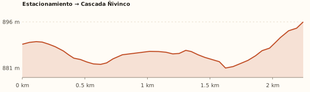
Elevation

Trail profile

Elevation profile: Parking → Ñivinco Waterfall

Parking → Ñivinco Waterfall

Length
2.3 km
Elevations
≈890 → 896 m
Elevation gain
+20 m
Uphill
≈40 min
Downhill
≈35 min
Difficulty
Easy to moderate
  1. Right after leaving the car you ford the first stream: it is narrow and cold; during the snowmelt it carries more water.
  2. Follow the numbered yellow markers through a forest of ñire trees and cane.
  3. When you reach the stream, the trail narrows and follows it under a tunnel of ñires to a pebble beach facing the falls.
  4. To climb to the viewpoint, cross from one side of the stream to the other on the flat stones.

Measured on OpenStreetMap trails. The Park sign gives 2 h round trip; guidebooks, 40 minutes one way at an easy pace. Times calculated at an easy pace, without stops.

Location and directions

How to get there

You arrive at: National Park sign (trailhead). Next to Route 40, on the left heading north, at the end of a short dirt turn-off. There is a National Park sign and a wooden stile.

Car

≈128 km · about 2 h 15

Where to park: Next to the Park sign
Space to leave the car by the side of the track. View on Google Maps
Do not leave anything in sight.
  1. Leave Bariloche towards Dina Huapi and follow Route 40 to Villa La Angostura (signposted), along the north shore of Nahuel Huapi.
  2. It is about 83 km to El Cruce, the centre of Villa La Angostura (≈1 h 20, all paved).
  3. At El Cruce take Route 40 north: the Seven Lakes Road, towards San Martín de los Andes. You pass lakes Correntoso and Espejo.
  4. About 44 km after El Cruce (≈6 km before the Pichi Traful river bridge) a dirt track turns off to the left.
  5. A few metres in is the National Park sign: leave the car there.
Open this route in Google Maps
Ratings from 1 to 5

What it's like, in numbers

How crowded is it?2/5
Very few peopleVery crowded

Few people. Little known; some people in January and February.

How physically demanding is it?2/5
Very easyVery hard

Short, flat walk. An almost flat 40-minute walk, with one stream crossing.

How much nature is there?5/5
Very littleA lot

Pure nature. National Park forest and a mountain stream.

Does it work on a windy day?4/5
Very exposedVery sheltered

Sheltered. Forest and ravine. To be checked

Is it easy to get there without a car?1/5
HardVery easy

Vehicle only. By car only, or on a Seven Lakes tour.

Are there facilities?1/5
NoneFull

None. Nothing: bring everything.

Is it good with kids?3/5
Not recommendedIdeal

With supervision. Short, but with a stream crossing and slippery rocks.

How warm is the water?1/5
FreezingMild

Cold (big lake). Snowmelt water, very cold. To be checked

In 10 seconds

What you want to know

Does it cost money?

Free!

We found no access fee for the trail.

  • EntryARS 0No fee at the entrance (guidebooks and Park sign). To be checked
  • Fuel≈255 km round tripFill up in Villa La Angostura. To be checked

Can I bring my dog?

Not allowed

Leave it at home: it is a National Park.

What the rules say

It is inside Nahuel Huapi National Park, where pets are not allowed, except guide dogs. The trail sign prohibits them, along with fires and camping.

What happens in practice

In February 2026 National Parks issued another warning about dogs after one bit a park ranger (ANBariloche).

Context

Pets are not allowed in Nahuel Huapi National Park or in Llao Llao Municipal Park (guide dogs only).

What's the easiest way to get there?
By car

No bus nearby: the closest stop is 10 km away.

How long does it take?
6 h 30 to a full day

On site 2 to 4 h + 2 h 15 by car each way.

Can you go and come back from Bariloche in one day?
Yes, it is a long day

It is about 128 km each way (2 h 15). Combine it with Villa La Angostura or the Seven Lakes.

Do you have to cross water?
Yes, a narrow stream

You ford it at the start. It is not hard, but the water is cold and carries more during the snowmelt.

Are there toilets or food?
No, bring everything

None. None: bring a packed lunch.

When is the best time?
Good time right now

October to May (moderate according to the Park sign). From June to September it becomes difficult, with ice and snow.

What people say

Reviews

What media, guides and visitors say
Media, guides and forums

“Very well-marked trail; about 40 minutes at an easy pace to the waterfall.”

Welcome Argentina
Media, guides and forums

“Easy or moderate depending on which paths you take between the different levels of the stream.”

Interpatagonia
Media, guides and forums

“Park sign: 2 h round trip, moderate from October to May and difficult from June to September.”

Foto del cartel (Thomas Woodtli, Wikimedia Commons)
All reviews and photosOpen Ñivinco Waterfall (Seven Lakes Road) in Google Maps

If you like this place…

Fact sheet

Type
Waterfalls · Hiking and walks
Activities
Walk · Waterfall · Picnic · Seven Lakes Road
Area
Seven Lakes Road · Neuquén · Nahuel Huapi National Park
Location
On Route 40 (Seven Lakes), about 6 km south of the Pichi Traful river bridge
Distance from the Civic Center
127.8 km · 2 h 15 by car
Time on site
2 to 4 h (1 h 15 of walking round trip, plus time at the waterfall; 2 h 15 by car each way)
Whole outing by car
6 h 30 to a full day
Trail length
≈2.3 km one way (≈4.6 km round trip)
Route type
Out and back
Elevation gain
Almost flat (≈20 m)
Elevation
≈890 m · max. ≈900 m
Difficulty
Moderate from October to May; difficult from June to September (Park sign)
Terrain
Forest trail with log steps; one stream to ford
Signposting
Numbered yellow markers and Park signs
Water on the way
Ñivinco stream
Meeting point
Arranged when you book
Toilets
No · None
Food
No · None: bring a packed lunch
Lifeguards
No · None
Shade
Yes · Forest
Phone signal
No · No signal along most of the Seven Lakes Road
Best months
Oct, Nov, Dec, Jan, Feb, Mar, Apr, May
Dogs
Not allowed
Cost
Free
Data checked on
November 19, 2026

What to bring

  • Shoes that can get wet, or sandals for the stream crossing
  • Packed lunch and mate
  • Light jacket
  • A bag to carry out your rubbish

Tips

  • Combine it with the Seven Lakes Road or an afternoon in Villa La Angostura.
  • Fill up in Villa La Angostura: there are no petrol stations on the road.
  • The michay bushes along the trail have little purple berries in summer.

Safety

  • Wet rocks are very slippery.
  • If the stream is high, do not cross it.
  • In winter there is ice: the Park rates it difficult.
Sources for this page (6)

Most sources are in Spanish.

Photos: Thomas Woodtli (CC BY-SA 2.0), Brian Ralphs (Flickr) (CC BY 2.0), Brian Ralphs (Flickr) (CC BY 2.0), Brandon Antonio Segura Torres y Priscilla Vieto Bonilla (CC BY-SA 4.0), Thomas Woodtli (CC BY-SA 2.0), via Wikimedia Commons.