“Moderate because of the gradient; no fires or overnight stays; few signs and not advisable in winter.”
Inacayal Waterfall and Belvedere Viewpoint (Villa La Angostura)
A fall of about 50 m in a forested ravine, an hour's climb from Villa La Angostura, with a viewpoint over Nahuel Huapi on the way
Great for
A 45 to 50 m drop.
The Belvedere is on the same trail.
About 230 m of elevation gain.
Not for: Going without cash: the community charges an entrance fee · Winter: snow builds up · People who do not want to climb slopes
What to do there
Three kilometres from the centre of Villa La Angostura, a trail climbs steeply through tall forest to a fork: one way leads to the Belvedere Viewpoint, a clearing overlooking the northern arm of Nahuel Huapi, the Correntoso river and its lake; the other to the Inacayal waterfall, which drops about 50 m into a damp ravine full of ferns.
The walk crosses land of the Paicil Antriao Mapuche community, which runs an information hut and parking area at the start and charges an entrance fee. There are few signs. You can add the Falso Filo del Belvedere, a longer and harder hike starting from the same place.
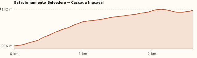
Trail profile
Parking → Inacayal Waterfall
- Length
- 1.9 km
- Elevations
- 915 → 1.135 m
- Elevation gain
- +230 m
- Uphill
- ≈1 h
- Downhill
- ≈45 min
- Difficulty
- Moderate
- From the information hut, the trail climbs steeply through tall forest.
- At the T-junction, right goes to the waterfall (left, to the viewpoint).
- You pass some settlers' houses and enter a denser forest down to the Las Piedritas stream.
- Follow the stream upstream to the ravine and the fall.
Parking → Belvedere Viewpoint
- Length
- 1.4 km
- Elevations
- 915 → 1.085 m
- Elevation gain
- +170 m
- Uphill
- ≈45 min
- Downhill
- ≈30 min
- Difficulty
- Moderate
- At the T-junction, turn left.
- A wide clearing overlooking the northern arm of Nahuel Huapi, the river and Lake Correntoso.
Measured on OpenStreetMap trails; the profile shows the loop via the viewpoint (2.6 km to the waterfall). Welcome Argentina and Interpatagonia rate it moderate because of the gradient. Times calculated at an easy pace, without stops.
How to get there
Car
≈87 km · 1 h 30
- Leave Bariloche towards Dina Huapi and follow Route 40 to Villa La Angostura (signposted), along the north shore of Nahuel Huapi.
- It is about 83 km to El Cruce, the centre of Villa La Angostura (≈1 h 20, all paved).
- At El Cruce take Route 40 north (avenida Siete Lagos) and, after about 800 m, turn right into the Epulafquen neighbourhood (calle Ignacio Antriao).
- Follow the signs to the information hut and parking area.
Bus + remis
Bus to Villa La Angostura (≈1 h 30) + about 3 km on foot or by remis from El Cruce
- Long-distance buses leave the Bariloche bus terminal for Villa La Angostura (about 1 h 30; check times at the terminal).
- About 3 km on foot or by remis from El Cruce.
The trail
1.9 km to the waterfall · +230 m
- From the hut, the trail climbs steeply through the forest.
- At the T-junction: left to the Belvedere Viewpoint; right to the waterfall.
- Towards the waterfall you pass some houses and enter a dense forest down to the Las Piedritas stream; follow it upstream to the fall.
- There are few signs: download the map beforehand.
What it's like, in numbers
Moderately busy. Fairly busy in summer, especially the viewpoint.
Slopes or uneven ground. An hour of steep climbing.
Mostly natural. Forest and stream, with settlers' houses along the way.
Sheltered. Dense forest; the viewpoint is more exposed. To be checked
Car yes, bus stop far away. Bus to Villa La Angostura and about 3 km on foot or by remis (private car) to the start.
Minimal. Information hut and parking; nothing else.
With supervision. Kids who walk well: the climb is tiring.
What you want to know
Does it cost money?
The Paicil Antriao Mapuche community charges an entrance fee: ARS 1,000 per person on foot and ARS 5,000 per car (sign reported in January 2026). There has been no official statement on the fee.
- Entry on footARS 1,000Per person (Diario Andino, Jan. 2026).
- Car (parking)ARS 5,000Per vehicle (Diario Andino, Jan. 2026; also listed in OpenStreetMap).
Can I bring my dog?
Ask at the entrance hut; if you bring one, keep it on a lead. To be checked
What the rules say
We found no published rule. The trail crosses land of a Mapuche community, with settlers' houses and animals.
What happens in practice
Guidebooks do not mention it.
Context
Pets are not allowed in Nahuel Huapi National Park or in Llao Llao Municipal Park (guide dogs only).
- What's the easiest way to get there?
- By car
No bus nearby: the closest stop is 10 km away.
- How long does it take?
- 5 h to a full day
Round-trip walk 2 a 4 h + 1 h 30 by car each way.
- Is there an entrance fee?
- Yes, to the community
ARS 1,000 on foot and ARS 5,000 per car, according to the sign reported in January 2026. Bring cash.
- Can you go and come back from Bariloche in one day?
- Yes
It is 87 km each way (1 h 30). Combine it with the Río Bonito waterfall or the village centre.
- Are there toilets or food?
- No, bring everything
We found no public toilets. None: bring water and a packed lunch.
- When is the best time?
- Good time right now
Spring to autumn. In winter snow builds up and it is not advisable (Interpatagonia).
Reviews
“The community put up a sign with fixed fees: cars ARS 5,000 and pedestrians ARS 1,000.”
“A waterfall of about 50 metres; the trail is well signposted and can be combined with the Falso Filo del Belvedere.”
If you like this place…
Refugio Piltriquitrón and the Bosque Tallado (El Bolsón)
Great for: a short walk with a big view · art in the mountains
Río Bonito Waterfall (Cerro Bayo)
Great for: a powerful waterfall without walking · combining with Inacayal
Bahía López and the Brazo Tristeza Viewpoint
Great for: kayaking or SUP in calm water · one of the best views of the lake
Fact sheet
- Type
- Waterfalls · Hiking and walks · Viewpoints
- Activities
- Half-day hike · Waterfall · Viewpoint · Forest
- Area
- Villa La Angostura · Neuquén
- Location
- On the slopes of Cerro Belvedere, on the Las Piedritas stream, on land of the Paicil Antriao Mapuche community
- Distance from the Civic Center
- 86.6 km · 1 h 30 by car
- Time round-trip walk
- 2 a 4 h (1 h 45 to the waterfall only; 2 h 30 to 3 h if you add the viewpoint)
- Whole outing by car
- 5 h to a full day
- Trail length
- ≈1.9 km to the waterfall; ≈4.5 km with the viewpoint
- Route type
- Out and back, or a loop via the viewpoint
- Elevation gain
- ≈+230 m
- Elevation
- ≈915 m · max. ≈1.140 m
- Difficulty
- Moderate: the climb is steep
- Terrain
- Dirt and leaf trail, steep at first
- Signposting
- Few signs: carry the map on your phone
- Water on the way
- Las Piedritas stream (no water in the first part)
- Meeting point
- Arranged when you book
- Toilets
- No · We found no public toilets
- Food
- No · None: bring water and a packed lunch
- Lifeguards
- No · Not applicable
- Shade
- Yes · Forest
- Phone signal
- Yes · Some signal near the village
- Best months
- Oct, Nov, Dec, Jan, Feb, Mar, Apr, May
- Dogs
- Ask first
- Cost
- ARS 1,000 on foot · ARS 5,000 per car
- Data checked on
- November 19, 2026
What to bring
- Cash for the entrance fee
- Water: there are no streams in the first part
- Hiking shoes
- A warm layer for the viewpoint
Tips
- Do the viewpoint first and then the waterfall: that is the order guidebooks suggest.
- Combine it with the Río Bonito waterfall, 10 minutes away by car.
- Respect the settlers' houses and animals.
Safety
- No fires or overnight stays.
- There are few signs: do not leave the trail.
Sources for this page (6)
Most sources are in Spanish.
- Mirador Belvedere y cascada Inacayal – Interpatagonia · s/f
- Trekking al mirador Belvedere y cascada Inacayal – Welcome Argentina · s/f
- Vecinos denuncian que la comunidad cobra entrada y estacionamiento en la Cascada Inacayal – Diario Andino · 20/01/2026
- Falso Filo del Belvedere – Diario Río Negro · 2026
- Distancias en auto desde el Centro Cívico (OSRM sobre OpenStreetMap) · 19/11/2026
- Medición propia: Estacionamiento → Mirador Belvedere → Cascada Inacayal (BRouter sobre senderos de OpenStreetMap + modelo de terreno SRTM) · 19/11/2026
Photos: Claudio Elias (Dominio público), Claudio Elias (Dominio público), Claudio Elias (Dominio público), via Wikimedia Commons.