“No booking needed: they say they never turn anyone away.”
Refugio Los Laguitos (El Bolsón)
The far end of the Circuito Troncal: on the shore of Lago Lahuán, facing Cerro Año Nuevo, 27 km from Wharton
Great for
Hut to hut up the Azul river valley.
Kayak rental by the hour.
Not for: Bringing a dog · Having only one day · Going without cash
What to do there
A hut among forests, wet meadows and glacial lakes at the end of the valley. It offers meals, a small shop and kayak rental by the hour, and has private double rooms subject to availability.
There's a single trail in, which is also the way back. If you don't want to do it in one go, sleep at El Retamal, La Horqueta, Los Mañíos, Casa de Campo or Del Conde. From the hut you can continue to Lago Soberanía (2 h), where a new hut opened in October 2026, and to Cerro Año Nuevo (8 to 9 h, moderate to hard).
The hut: booking, food and facilities
- Mandatory registration
Before you set off, register at anprale.com (free, with daily quotas) and submit the descent notice when you get back.
- Booking
Not needed: they say they never turn anyone away. There's a WhatsApp number for bookings only (+54 9 2944 28-3526).
- Check-in
Until 10 pm.
- Where to sleep
Bunks with mattresses (bring a sleeping bag), double room and camping.
- They don't rent
Tents, sleeping bags or stoves. No pets allowed.
- Stopovers
La Horqueta and Del Conde hadn't confirmed opening as of 18/11/2026; Los Mañíos did publish prices.
- Payment
Cash only: there's no signal or internet.
- Contact
@refugioloslaguitos
The hut's season information (Nov. 2026).
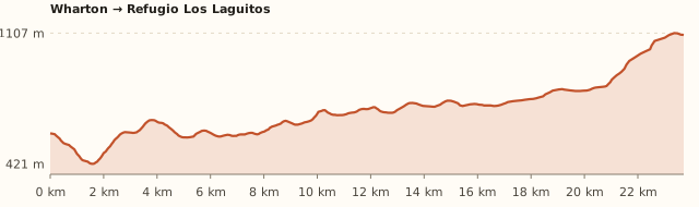
Trail profile
Wharton → Refugio Los Laguitos
- Length
- 23.7 km
- Elevations
- 580 → 1.100 m
- Elevation gain
- +975 m / −455 m
- Out
- ≈9 h
- Back
- ≈7 h 40
- Difficulty
- Hard
- Wharton – La Playita 6.5 km (2 to 3 h) – La Tronconada 1.5 km – Cajón del Azul 2 km.
- El Retamal 3 km (1 h) – La Horqueta 6 km – Los Mañíos 3 km (45 min).
- Los Laguitos 5 km more (2 to 3 h).
Measured on OpenStreetMap trails. The hut gives 27 km and 8 to 10 h one way; Argentina Trekking, 1,400 m of cumulative climbing. Times calculated at an easy pace, without stops.
How to get there
Car or remis
≈110 km · 1 h 40 from Bariloche to Wharton
- Take Ruta 40 south to El Bolsón (about 120 km).
- Before reaching downtown, follow the signs to Wharton / Cajón del Azul, heading northwest.
- It's 14 km from El Bolsón to Chacra Wharton, where the trail begins.
- In El Bolsón you can also take a remis to Wharton.
Coach + local bus
Coach to El Bolsón (≈2 h) + local bus or remis to Wharton
- Long-distance coaches to El Bolsón leave from the Bariloche bus terminal (about 2 h).
- In El Bolsón, on plaza Pagano, there's a La Golondrina stop with a "a Wharton" sign (undated guide: check the times at the tourist office).
- The other option is a remis to Wharton (14 km).
The Circuito Troncal
24 to 27 km · 8 to 10 h one way
- Wharton → La Playita 6.5 km (2 to 3 h) → La Tronconada 1.5 km → Cajón del Azul 2 km.
- El Retamal 3 km (1 h) → La Horqueta 6 km → Los Mañíos 3 km (45 min).
- Los Laguitos 5 km more (2 to 3 h), first along the Azul river and then the Rayado.
What it's like, in numbers
Almost always empty. Very few people: it's the far end of the valley. To be checked
Full day with steep climbing. 27 km one way.
Pure nature. Forests, wet meadows and glacial lakes.
Sheltered. The Azul river valley is sheltered by the forest. To be checked
Vehicle only. Far from Bariloche and from the trailhead.
Some. Meals, shop, shower and kayaks.
Not recommended. Not recommended for kids. To be checked
What you want to know
Does it cost money?
Hiking up is free. A bed costs ARS 60,000 and camping ARS 30,000 per person; a private double room, ARS 150,000 (Nov. 2026).
- ANPRALE registrationFreeMandatory and personal, before you go up, at anprale.com. There are daily quotas. When you come back, submit the "descent notice" with your registration number.
- Bed (with kitchen and hot water)ARS 60,000
- Camping (covered area with wood-fired kitchen)ARS 30,000
- Private double roomARS 150,000Subject to availability.
- MealsARS 20,000 a ARS 35,000Breakfast, lunch or dinner. Shower and phone charging extra.
- Los Mañíos (stopover)ARS 40,000Bed with shower and breakfast; camping ARS 20,000 (Sept. 2026, Guía Patagonia Andina).
Can I bring my dog?
Leave your dog at home: the huts won't take it.
What the rules say
It is inside the Río Azul – Lago Escondido Protected Natural Area (ANPRALE). The huts on the circuit don't accept pets (Hielo Azul, El Retamal, Los Laguitos and La Horqueta say so explicitly).
What happens in practice
The huts ask you to come without a dog: there is native wildlife (huemul, pudú) and they have nowhere to keep them.
Context
Pets are not allowed in Nahuel Huapi National Park or in Llao Llao Municipal Park (guide dogs only).
- What's the easiest way to get there?
- By car
No bus nearby: the closest stop is 10 km away.
- How long does it take?
- 2 to 3 days
Traverse 8 to 10 h one way from Wharton; you can split it by sleeping along the way, plus the trip to the meeting point.
- Do I need to register?
- Yes, at anprale.com
It's mandatory, free and with daily quotas. When you come back, submit the descent notice.
- Do I need to book?
- Not needed
There's a WhatsApp number for bookings only, but they say there's always room.
- Can I do it as a day trip?
- No
It's 27 km one way: a 2- to 3-day traverse.
- Are there toilets or food?
- Yes
At the hut (shower extra). Meals and a small shop.
- When is the best time?
- Good time right now
Opens on 10 October and closes after Easter (hut).
Reviews
If you like this place…
Refugio Lago Natación (El Bolsón)
Great for: sleeping up high · a hut-to-hut traverse
Refugio Lago Soberanía (El Bolsón)
Great for: the full Circuito Troncal traverse · visiting the new hut
Refugio Hielo Azul (El Bolsón)
Great for: seeing a glacier up close · a hut-to-hut traverse
Fact sheet
- Type
- Mountain huts · Hiking and walks · Lakes and lagoons
- Activities
- 2- to 3-day traverse · Overnight in a mountain hut · Camping · Kayak · Glacial lakes
- Area
- El Bolsón · ANPRALE (110 km from Bariloche)
- Location
- On the shore of Lago Lahuán, facing Cerro Año Nuevo, at about 1,100 m
- Distance from the Civic Center
- 110.6 km · 1 h 36 by car
- Time traverse
- 2 to 3 days (8 to 10 h one way from Wharton; you can split it by sleeping along the way)
- Whole outing by car
- 2 to 3 days
- Trail length
- ≈24 to 27 km one way
- Route type
- Out and back along the Circuito Troncal's single trail
- Elevation gain
- ≈+1,000 to +1,400 m cumulative
- Elevation
- ≈580 m at Wharton · max. ≈1.100 m
- Difficulty
- Hard because of its length
- Terrain
- Forest trail, wet meadows and stream crossings
- Signposting
- Signposted Circuito Troncal
- Water on the way
- Water at many points along the way
- Meeting point
- Arranged when you book
- Toilets
- Yes · At the hut (shower extra)
- Food
- Yes · Meals and a small shop
- Lifeguards
- No · Not applicable
- Shade
- Yes · Forest almost all the way
- Phone signal
- No · No signal in the valley
- Best months
- Nov, Dec, Jan, Feb, Mar, Apr
- Dogs
- Not allowed
- Cost
- Free to hike up
- Data checked on
- November 19, 2026
What to bring
- Sleeping bag (no bedding provided)
- Cash for everything
- Hiking boots
- Rain jacket and warm layers
- Headlamp
- A tent as plan B if the hut doesn't take bookings
Tips
- Split it over two days, sleeping at El Retamal or Los Mañíos.
- Rent a kayak on the lake in the afternoon.
Safety
- Register at anprale.com before setting off and submit the descent notice when you get back.
- Don't make fires outside the designated fire pits: there were serious fires in the area in 2025.
- In heavy rain the area may close: check with El Bolsón's mountain information office (+54 294 445-5336).
- Cerro Año Nuevo is moderate to hard: check whether there's snow.
Sources for this page (6)
Most sources are in Spanish.
- Refugio Los Laguitos – Argentina Trekking (precios y datos del refugio, nov. 2026) · consultado 19/11/2026
- Refugio Los Mañíos – Argentina Trekking (precios y datos del refugio, nov. 2026) · consultado 19/11/2026
- Registro obligatorio de visitantes – ANPRALE (Río Negro) · consultado 19/11/2026
- Reabrió el ANPRALE en El Bolsón: cómo registrarse – Noticias Ambientales · 21/09/2026
- Refugios de El Bolsón: estado y precios 2026/27 – Guía Patagonia Andina · act. 18/09/2026
- Medición propia: Wharton → Los Laguitos (BRouter sobre senderos de OpenStreetMap + modelo de terreno SRTM) · 19/11/2026
Photos: Mcampo (CC BY-SA 4.0), via Wikimedia Commons.