All places

Fishing season open until May 1

Lake Gutiérrez shore hike to Playa Muñoz

Away from the usual beaches: coihue forest, the lake by your side and a hidden beach at the end

Great for

A full hiking day with a beach

5.8 km one way and a beach almost to yourself at the end.

Being alone with the lake

Few people make it to Playa Muñoz.

Combining

Cascada de los Duendes and the Lake Gutiérrez Viewpoint start from the same place.

A short walk with kids

The shore version: 2.2 flat km.

Not for: Going with a dog: it is a National Park · Going when you are short on time · Going without water: little shade at the start

The experience

What to do there

Instead of the well-known beaches of Lake Gutiérrez, this outing follows the lake's west shore inside the National Park. It starts at the ranger station and the Lago Gutiérrez campground, climbs through the forest and, at a signposted fork, drops quickly down to Playa Muñoz, a hidden beach you can only reach on foot or by boat.

The first stretches have little shade because of an old wildfire. For kids or anyone who doesn't want the full hike, there is a short version: 2.2 flat kilometers along the shore road from Villa Los Coihues, with small beaches and lake views.
Elevation

Trail profile

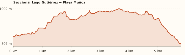
Elevation profile: Lake Gutiérrez ranger station → Playa Muñoz

Lake Gutiérrez ranger station → Playa Muñoz

Length
5.8 km one way
Elevations
846 m → max. ≈1,000 m → 807 m (lake)
Elevation gain
+≈300 / −≈340 m one way
Out
≈2 h 30
Back
≈2 h 30
Difficulty
Moderate (Nov.–Apr.), hard (May–Oct.)

Short version: Villa Los Coihues → ranger station along the shore

Length
2.2 km
Elevations
Flat
Elevation gain
—
Out
≈30 min
Back
≈30 min
Difficulty
Very easy

Bariloche Trekking gives 170 m of elevation gain and 5 h round trip; the model adds more meters because it counts the intermediate ups and downs. Times calculated at an easy pace, without stops.

Location and directions

How to get there

You arrive at: Lake Gutiérrez ranger station (start). Next to the Lago Gutiérrez campground. The trail is the "Sendero Frey por Gutiérrez".

Car, taxi or remis

16.1 km · about 26 min (the last 2.2 km on gravel)

Where to park: Next to the ranger station
Free parking. View on Google Maps
You will be away for several hours: leave nothing visible.
  1. Take Route 82 to Villa Los Coihues.
  2. Continue on the gravel shore road to the ranger station.
Open this route in Google Maps
For anglers

Fishing: rules and tips

Fishing season open until May 1

What you can catch

Rainbow and brown trout

Methods

Fly, spinning and trolling

What you can keep

2 trout per day. In May and October 2027, catch-and-release, no trolling or motors.

Season

Season from November 1 to May 1

Hours

Daylight only: from morning twilight to evening twilight (National Park). In mid-November, ≈05:45 to 21:15; in January, ≈06:00 to 21:50.

Where from

From the shore of Lake Gutiérrez.

Lures and flies that work

Spoon lures and streamers.

Best time

Early, before the wind.

Jurisdiction

National Park

Rules for this spot

  • Lake Gutiérrez (National Park): 2 trout per day; trolling allowed.
  • No fishing within 200 m of stream mouths in May and October.
  • Artificial lures only, with a single hook and one rod per person: bait is banned.
  • Perch, silverside, puyén and Atlantic salmon must always be released.
  • Felt-soled wading boots and lead weights are banned.
  • Didymo: before moving to another river or lake, disinfect your gear (30 min in 10 litres of water with 200 ml of bleach) or let it dry for 48 h.

Watch out

  • Do not confuse it with the Gutiérrez stream, which flows out of the lake past the Paseo de la Usina: fishing is banned there.
  • Didymo is present in the area: disinfect your gear.

Licence

Required. One licence covers Río Negro, Neuquén, Chubut and the National Parks. Foreign visitors: ARS 50,000 a day, ARS 140,000 for 10 days, ARS 280,000 for the season (Argentines: ARS 12,500 / 25,000 / 50,000). Carry it with your ID. Wardens: 0800-777-3722.

Get the licence

Patagonian Freshwater Fishing Regulations 2026/27. Rules change every season: check them before you go.

Ratings from 1 to 5

What it's like, in numbers

How crowded is it?2/5
Very few peopleVery crowded

Few people. Very few people at Muñoz; a few more at the ranger station in summer.

How physically demanding is it?4/5
Very easyVery hard

Several hours or a lot of climbing. 5 h round trip, with a climb and a steep descent at the end.

How much nature is there?5/5
Very littleA lot

Pure nature. National Park forest and a beach without buildings.

Does it work on a windy day?3/5
Very exposedVery sheltered

Some shelter. Forest, but the beach faces the lake. To be checked

Is it easy to get there without a car?3/5
HardVery easy

Bus + 1–3 km walk. Bus plus a 3 km walk to the start.

Are there facilities?1/5
NoneFull

None. Nothing at the beach; the campground at the start has toilets and a small store.

Is it good with kids?2/5
Not recommendedIdeal

Older kids only. Older kids only; for small kids, the short version.

In 10 seconds

What you want to know

Does it cost money?

Free!

We found no fee at the ranger station.

  • EntranceARS 0We found no fee at this National Park entrance. To be checked
  • Trekking registrationFree and mandatoryIn October 2026 National Parks fined a tourist who got injured walking down to Playa Muñoz without having registered.
  • ParkingARS 0Next to the ranger station.
  • Bus (one way)ARS 2,333.30With a SUBE card. Standard fare for sections I to III; residents with a registered SUBE card ARS 1,749.98 (since 30/07/2026).
  • Fishing licence (per day)ARS 12,500Argentines: ARS 12,500 a day, ARS 25,000 for ten days, ARS 50,000 for the season. Foreigners: ARS 50,000, ARS 140,000 and ARS 280,000. Free but still required for under-12s, over-65s and retirees. One licence covers Río Negro, Neuquén, Chubut and the National Parks: permisosdepesca.com.ar.

Can I bring my dog?

Not allowed

Leave your dog at home: it is a National Park.

What the rules say

It is inside Nahuel Huapi National Park (measured with the official boundaries on OpenStreetMap), where pets are not allowed, except guide dogs. The short shore version is a grey area: the Villa Los Coihues road is outside the Park, but the ranger station is already National Park.

What happens in practice

In February 2026 National Parks issued another warning about pets entering the park, after a dog bit a ranger (ANBariloche).

Context

Pets are not allowed in Nahuel Huapi National Park or in Llao Llao Municipal Park (guide dogs only).

What's the easiest way to get there?
By car

No bus nearby: the closest stop is 3 km away.

How long does it take?
6 h to a full day

Walking 5 a 6 h 30 + 26 min by car each way.

Can I fish today?
Yes, open until May 1

Fly, spinning and trolling. 2 trout per day. In May and October 2027, catch-and-release, no trolling or motors.

Are there toilets or food?
Yes

At the campground at the start. Campground store in season.

When is the best time?
Good time right now

November to April. From May to October it gets harder (mud, snow).

What people say

Reviews

What media, guides and visitors say
Media, guides and forums

“At the signposted fork, left goes to Playa Muñoz and right to Refugio Frey; the final stretch drops quickly through coihue forest.”

Bariloche Trekking
All reviews and photosOpen Lake Gutiérrez shore hike to Playa Muñoz in Google Maps

If you like this place…

Fact sheet

Type
Hiking and walks · Beaches · Lakes and lagoons · Fishing
Activities
Full-day hike · Hidden beach · Shore of Lake Gutiérrez · Fishing (with a licence)
Area
Lake Gutiérrez · west shore
Location
Starts at the Lake Gutiérrez ranger station, past Villa Los Coihues
Distance from the Civic Center
16.1 km · 26 min by car · 3 h 28 on foot
Time walking
5 a 6 h 30 (round trip, with some time on the beach)
Whole outing by car
6 h to a full day
Trail length
5.8 km one way (11.6 km round trip) + 2.2 km if you start at Villa Los Coihues
Route type
Out and back
Elevation gain
+≈300 / −≈340 m one way
Elevation
≈846 m s.n.m. · max. ≈1.000 m s.n.m.
Difficulty
Moderate in summer, hard in winter
Terrain
Dirt and roots; steep descent at the end
Signposting
Signposted: at the fork, left to Playa Muñoz
Water on the way
Lake at the end; bring water
Nearby bus lines
41, 50 (stop 3 km away)
Gravel road
Yes, on the last stretch
Toilets
Yes · At the campground at the start
Food
Yes · Campground store in season
Lifeguards
No · None
Shade
No · Little shade in the first 2 hours
Phone signal
No · Unconfirmed
Fishing
Season from November 1 to May 1 · Fly, spinning and trolling
Best months
Nov, Dec, Jan, Feb, Mar, Apr
Dogs
Not allowed
Cost
Free
Data checked on
November 18, 2026

What to bring

  • Plenty of water
  • A hat and sunscreen: little shade at the start
  • Food for the day
  • Hiking shoes

Tips

  • Register your trek before setting out: it is mandatory and free.
  • Start early to get back in daylight.
  • Combine it with Cascada de los Duendes on the way back.

Safety

  • Always stay with your group: in October 2026 there was a search for a boy who got separated from his mother at the turnoff from Cascada de los Duendes.
  • Don't set out if there is a weather alert.
  • Camping and fires are not allowed.
  • Watch out for bikes crossing the trail.
Sources for this page (7)

Most sources are in Spanish.

Photos: MelisaMurillas (CC BY-SA 4.0), McKay Savage (CC BY 2.0), HGranger18 (CC BY-SA 4.0), CarlosJBJ (CC BY-SA 4.0), Amina Ferley Yael (CC BY-SA 4.0), via Wikimedia Commons.